At the last meeting our chairman Bill Bagley gave a very informative talk on Breccia and its formation.
He commenced by explaining what breccia is and how it differs from conglomerate which could possibly be confused with it.
Breccia may be defined as a rock composed of angular rock fragments set in a matrix of finer grained materials. The name Breccia comes from the Italian breccia for rubble. The angular nature of the fragments implies that the fragments are from a local source and have not travelled very far. Most breccias are sedimentary in origin but may also be formed from the in-situ breakup of local rocks.
Breccia can be confused with conglomerate. Both are composed of shards of rock set in a cement matrix. Breccia however is composed entirely of shattered angular clasts, whereas conglomerate is composed mainly of rounded clasts with occasional angular clasts. The angular clasts are created locally, but rounded clasts are created by transport and friction over a long distance
There are two main classes of breccia as far as their construction is concerned :
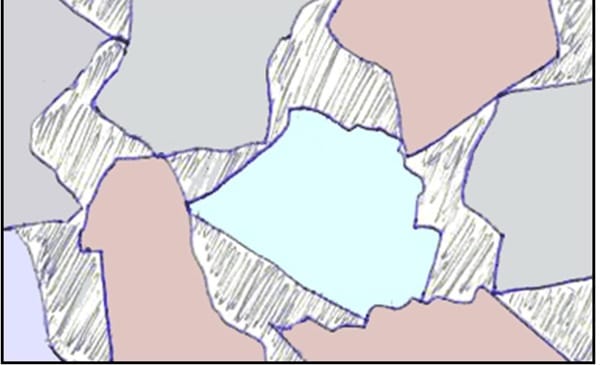
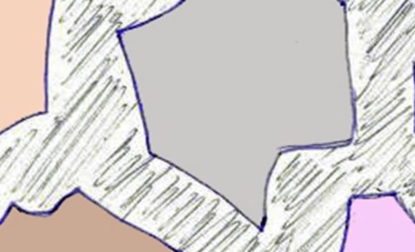
Clast supported — Where the clasts touch each other, and the matrix fills the voids.
Matrix supported — Where the clasts are not in contact and the matrix surrounds each clast.
Diagram showing clast and matrix supported breccia by Bill Bagley
The basic types of breccia are sedimentary (including Collapse), igneous, hydrothermal, tectonic, impact. However there are many variations of each type, very often named after the locality where they are found. There are literally dozens of breccias named after their locality, each one having it’s own distinctive appearance
Of all the different basic types of breccia sedimentary is probably the most common. There is so much erosion of surface rocks that this is hardly surprising. All types of rock, including the harder igneous rocks are subject to erosion from wind ice and rain. Just about every exposed hillside has some scree slopes. The steeper the hillside the more scree there is.
Very large accumulations of scree can occur as the result of debris flows. which are produced when a storm washes loose scree into swollen streams and rivers. The scree in the debris flow will be deposited on lower ground where the river widens, especially so in estuaries.
Coastal rocks are especially subject to erosion, mostly by wave and storm action. Most cliffs have freshly formed scree at their bases.
It is the accumulated scree from whichever source which will eventually, after a very long period of time become cemented to form breccia.
In a karst terrain, a collapse breccia may form due to collapse of rock into a sinkhole or in cave development. Another name for collapse breccia is “solution-collapse breccia”, because it is caused by dissolution of underlying soluble bedrock, such as limestone or dolomite. Once the groundwater has dissolved the soluble rock the non- soluble rocks collapse and become crushed.
Igneous breccia can be formed from rocks coming from two different origins, volcanic eruptions, or igneous intrusions, for this reason igneous breccia is commonly referred to as volcanic breccia. The volcanic breccias are the result of violent eruptions causing pyroclastic flows of fractured pieces of rock plucked from the wall of the magma conduit, mixed with a smaller amount of pieces of rock picked up by the lava as it flows down the volcano slopes. The resulting breccia is uniform in rock type
Volcanoes eject molten lava to the surface, whereas igneous intrusions occur when magma cools and solidifies before it reaches the surface. Igneous intrusions are often the result of more than one episode of intrusion into the same fault and when new hot magma intrudes into previously cooled magma, fracturing occurs, especially around the outer edges of the intrusion, and it is this outer fractured rock which later becomes brecciated.
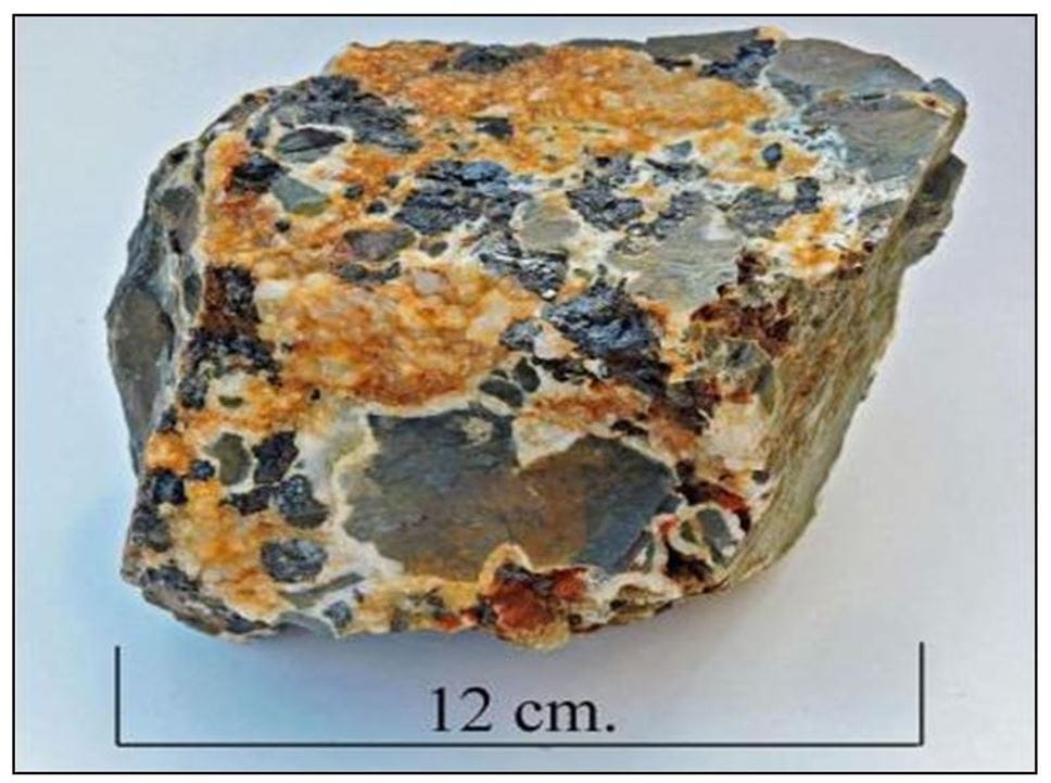
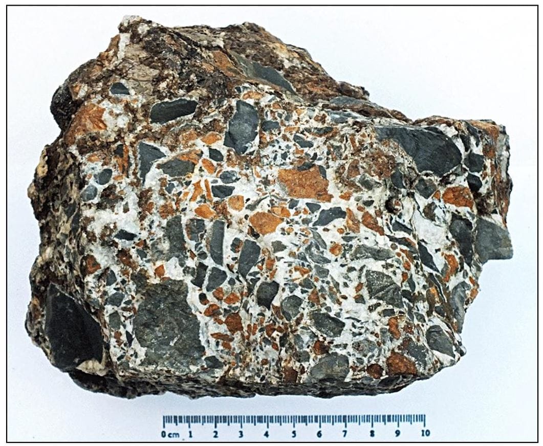
Hydrothermal breccia from Bryn-y-Rafr mine west Wales by Bill Bagley
Hydrothermal breccias occur at relatively shallow depths in the Earth’s crust, at temperatures between 150 oC and 350 oC. Fractures in the rock are home to circulating hot fluids, very often mineralised. As with any hot or boiling fluid, expansion occurs, which causes extreme pressure to be exerted on the walls of the fracture by the fluid. If the extreme pressure exerted by the fluid is suddenly decreased, due to the fluid finding an escape route, the hydrofracturing process is triggered. The instantaneous decrease in pressure causes the fracture walls to shatter and implode rock fragments into the hot circulating fluid. The fluid, now carrying rock fragments will eventually cool and solidify, and a breccia is created.
In ore bodies the circulating fluid is usually rich in silica or calcite, but the fluid also carries other dissolved minerals, such as galena, copper, sphalerite, etc. which upon cooling crystallise, and become incorporated into the breccia
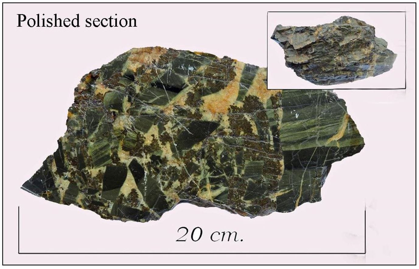
Vein breccia Cwmrheidol mine west Wales by Bill Bagley
Ferroan dolomite in hydrothermal breccia west Wales by Bill Bagley
Tectonic or fault breccia is formed by the action of the opposing walls of a fault grinding against each other. The cement may be the result of mineral matter introduced into ground water.
Impact breccia is not a common type of breccia because it is the product of immense heat and pressure generated by an asteroid strike, which fortunately does not happen very often.
Impact breccia is composed of shattered fragments of rock set in a crystalline matrix of melted rock, the composition of which can vary widely, dependant of the type of rock at the asteroid impact site.
71% of the Earth’s surface is covered by water, so it is inevitable that many asteroid strikes have been in the oceans which makes them much more difficult to observe.
A very interesting talk.
Tuesday 20th May 2025
At the April meeting Prof. David James gave a talk entitled: Some Structural and Mineralogical Problems in the Corris Slate Belt
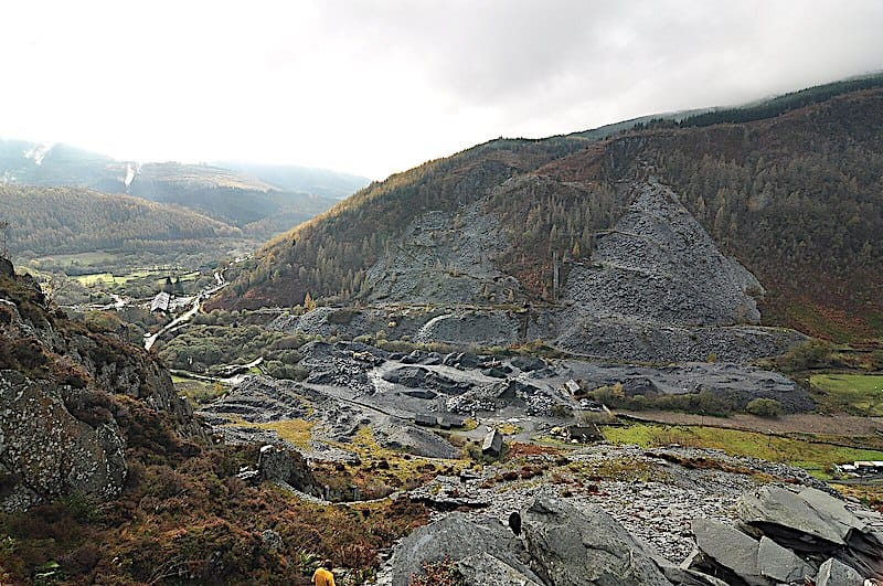
The talk centred on the area known as the Corris Slate Belt. This is an area between Dinas Mawddwy and Towyn which is on the slope of the Harlech Dome. The rocks are Upper Ordovician /Lower Silurian in age and are formed from deep water turbidites. The rocks form a homocline with a NE-SW trend. Two of the formations i.e. the Narrow Vein and the Broad Vein contained sufficient pure mud that workable slate was produced when metamorphosed. The narrow vein being of a higher quality of slate. At the base of the Broad vein lies the Nod Glas formation which is a characteristic black hemipelagic mudstone deposited in deep oxygen-poor conditions by quiet settling of suspended mud particles from the overlying column of seawater.
Prof. James then went on to point out that the anticlines in mid-Wales peter-out into this inclined belt. He then posed the question : “were the folds formed with the belt roughly horizontal and then tilted down to the south or did the folds develop on a homocline that already existed?”
He went on to suggest that during the deposition of these rocks the Bala - Tal y Llyn Fault (Bala Lineament) was active and downthrowing to the south.
Results from various studies actually suggest this to be the case. Metamorphic studies do suggest that there was movement of the fault during sedimentation. Measurements show that with increasing burial there was an increasing low grade metamorphism from the Dolgau Mudstones to the Nod Glas. But as the Bala fault is crossed the degree of metamorphism is reduced. This shows that by the time these rocks had metamorphosed the Bala fault had downthrown the sequence to its south against the sequence to its’ north before the final phase of Acadian heat.
Paleo-current studies also support this idea. If you observe the palaeocurrents i.e the distribution of the sandstones, their transport direction, the deep water passages and thickness in the sequence you can work out when the fault was quiescent and when it was moving.
Sediment was found to flow towards the fault and flow along the fault thus showing that the fault was moving.
Further it can be found that the area contains two basins. The main turbidite basin in central Wales and a smaller basin which is the Denbigh Trough and the dividing line being the Bala lineament.
He went on to discuss the 1923 paper by WJ Pugh. Here he pointed out that the axis of the Corris anticline was anomalous for which Pugh had suggested torsion had occurred in the axis.. This area became known as the “Corris Appendix”. Prof. James went on to show that unlike the surrounding area where the strike of the cleavage is axial planar the cleavage goes straight across the “appendix”. This suggests that ,if correct, the Corris anticline must be compound as it has an axial planar cleavage in one part but predates the cleavage in another. But this is irrational.
The dip on the anticline is shallow on one side but steep on the opposite limb. This has suggested the presence of faulting. The problem with the “appendix” can be resolved by the presence of a low angle reverse fault on the eastern portion of the anticline. Others had suggested the presence of a fault but had suggested that the fault was vertical but by going underground into the Garnedd Wen mine prof. James viewed the fault which did prove to be of a low angle. This fault can be traced approximately parallel to the bedding for some distance when it then merges with a second fault.
Before any folding occurred there was a syn-sedimentary slide off the Bala lineament which produced thickening in the hanging wall. So the Corris anticline was developed when the hanging wall sequence was backthrust over the footwall sequence during the Acadian deformation
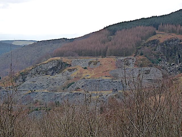
Prof. James went on to explain what he described as a geometrical puzzle and mapping problem at Aberllefenni where there is a repetition of the Narrow Vein.
The geological structure at Aberllefenni is again affected by faulting, which causes repetition of the Narrow Vein outcrop on the south of the valley. Therefore on the northern side by Foel Grochen there is only one outcrop of the Narrow vein but on the southern side of the valley the vein is repeated. Both Pugh 1923 and the BGS 1995 have presented ideas of what happens to cause the repetition but Prof. James suggests that they are both wrong. They suggested that the faulting is vertical and the fault displaces the rocks to the north as a downthrow but Prof James argues against this idea. He suggests the apparent downthrow to the north is the result of the bedding dipping more steeply than the fault plane.
He then made the prediction that the fault should come down into the valley and then climb out. So he went on an excursion into level one at Ceunant Ddu to find the fault. The fault was in the location that he predicted, showing Prof. James to be correct.
He ended with discussing scams that had occurred in the area when coal and gold where suggested to be present, shares bought and sold on speculation only for neither to be present.
A very interesting and informative talk.
Sunday 13th April 2025
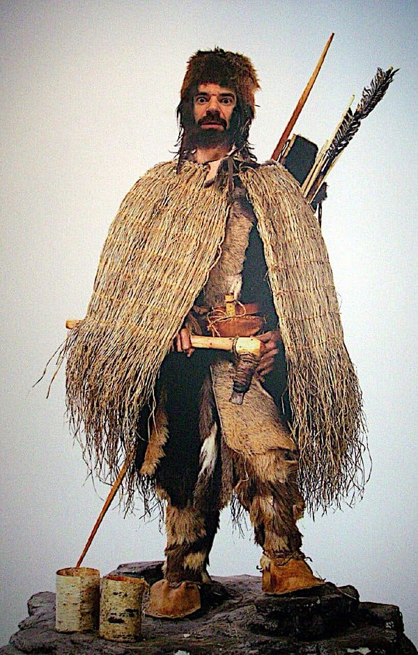
At the last meeting Prof Burek gave a fascinating talk about forensics used in the untangling of the case regarding Ötzi the Iceman a 5,300-year-old glacier mummy recovered at the Tisenjoch (South Tyrol Italy) in 1991.
The talk commenced by prof. Burek describing the history of the development of forensic science in general and that of geoforensics in particular.
One of the fundamental principles in forensic geology was devised by Dr Edmund Locard (1877-1966) when he became interested in dust being transferred during a crime. It was Locard who suggested that whenever two objects come into contact, there is always a transfer of material and it was this idea that led to the fundamental idea that every contact leaves a trace. He also set up his own police lab in his attic in Lyon in 1910. The science developed over time as methods and technology has improved and now forensic geologists are routinely used on cases.
Geoforensics (forensic geology/forensic geoscience) may be described as follows:
The application of geoscience information and methods to investigations which may come before a court of law.
It’s boundaries are not clearly defined
Mainly concerned with rocks, sediments, minerals, soils and dusts and also man-made materials where natural materials are an essential part eg. cement or bricks.
Can cover air and water
Geoscience is often used in environmental forensic cases.
Its main uses being in identifying material for a match and to indicate timing of an event. The purpose of a forensic geologist at a crime scene is to collect geological samples which may include samples of, for example, minerals, soils, sediments, rocks, or natural building materials (e.g. sand, gravel, building stone and slate) or material that is derived from geological raw material (e.g. glass, bricks, concrete, plaster board or tiles).
The body of Ötzi was found by two German hikers in 1991, whilst walking in the Ötztal Alps near the Austrian and Italian borders. His removal from the ice was difficult which led to some damage of the corpse. His remains were delivered to the Institute of Forensic Medicine in Innsbruck, Austria. He was moved to Italy where he was kept in a freezer at the South Tyrol Museum of Archaeology in Bolzano, Italy.
Not much research was done on the remains for about 25 years, after which forensic experts were brought in to unravel the mystery. Unlike mummies from dry climates, the organs, tissues, bones, and skin of this “wet mummy” were intact, right down to the contents of his stomach, which allowed a very detailed study to be undertaken.
The findings showed that he was about 45 years old, 5’3’’-5’5” tall, weighed 50kg, and suffered from arthritis: gallstones and whipworms. He had old wounds consisting of a frost-bitten little left toe and broken ribs. He also had very fresh wounds of a badly cut right palm inflicted less than 48 hours previously. He had 61 tattoos from head to foot which were the oldest tattoos ever found by about 2000 years. These were located in areas of joints and spine and may have been at acupuncture treatment points. Pollen analysis discovered 30 different types of pollen in his gut. These findings suggested that he died in spring or early summer. That in the 2 days before he died, he had traveled from an elevation of 6,500 ft down to the valley floor at about 5,000 ft, and then back up into the mountains at 10,500 ft. He had consumed ibex meat, einkorn wheat, fatty bacon or cheese, and flowering plants in one meal, and red deer meat and grass or cereal in another. His last meal was eaten about 30 minutes before he died. In 2001, a CT scan revealed a flint arrowhead in his left shoulder, and a puncture at the same spot was found when his coat was examined. This led to his death. Thus he was murdered.
Recent DNA analysis has revealed that Ötzi had dark skin and dark eyes. They also found that 92% of his ancestry comes from early Anatolian farmers who migrated out of modern-day Turkey about 8000 years ago. This is the highest percentage of Anatolian heritage yet recorded in an ancient European from Ötzi’s time. DNA also shows that he is most closely related to the inhabitants of Sardinia. He had a copper-bladed axe which was new technology that required special skills to extract and process the metal. This discovery drove our understanding of the Copper Age back by 1000 years.
The use of multi-disciplinary forensic techniques shows just how even the most coldest of cases can sometimes be unravelled.
Saturday 15th March 2025
Dinosaurs and Deserts in Wales by Cindy Howells palaeontology curator National Museum of Wales.
If you are hoping to find fossils of dinosaurs or perhaps fossil trackways in Wales then in you have to travel to the SE of Wales to the Mesozoic rock outcrops that possibly contain them. The area is a narrow wedge situated between Cardiff and Porthcawl.
The first evidence of dinosaurs in the area was found in the form of footprints. A block consisting of a footprint trackway was found by TH Thompson in 1879 in a local churchyard Newton, near Porthcawl. He was a naturalist and recognised the similarity of these footprints to some recently described ones from America. He then worked in conjunction with prof.Sollas (1849 - 1936) from Bristol, to undertake further investigations of the footprints.
They not only concluded that these were dinosaur footprints but observed the similarity between these footprints and those made by flightless birds. In one experiment they persuaded an Emu to walk across wet cement to show the similarity. That was ingenious as it is the earliest idea of linking dinosaurs to birds. The prints were tridactyl, bipedal with a long central toe suggesting a Theropod dinosaur. The trace fossil itself is known as Anchisauripus.
Not only are Theropod tracks found in south Wales but bones from theropods have also been found. For example, in 1898 a fossil jaw was found by stonemasons in Bridgend and in 2012 a finger bone was discovered at Lavernock Penarth. Both of which were found in deposits of Rhaetian age (208.5-201.3 mya)
In 1879 another block of stone revealed fossil Anchisauripus but also two completely different sorts of prints. These latter prints are known as Eosauropus and will have been made perhaps by a Sauropodomorph dinosaur.
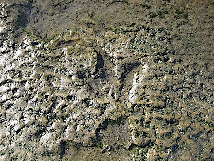
As footprints differ depending on the thickness, grain size and moisture content of the mud when they are made it is difficult to always get a really good impression of the foot that made it. But one was found by a four year old girl whilst out walking with her father during Covid lockdown, from which one could see the shape of the muscle pads, the joints and the claws. This was recovered and is now in the museum. On studying the fossil it was found that there was in fact two prints which showed that it was moving so that now the stride-length can be determined from which other measures can be deduced.
Another series of prints found by the public in 2023 occur at Penarth in redbeds similar to that which occurs at Bendricks bay. These have a very consistent stride-length but these prints are eroding very quickly.
If you go inland to the Carboniferous limestone quarries near Bridgend you will find Triassic material filtered down in fissures in the Carboniferous limestones. Here can be found bones of various creatures eg. The mammal Morganucodon oehleri. But also other finds.For example, In 1952 dinosaur bones were also found within these cave sytems eg. Pantydraco caducus a herbivore.But in 1921 they re-examined a few bones and found that they were in fact the bones of a theropod dinosaur known as Pendraig
In 2014 at Lavernock bone material was found after a rock fall which has been identified as a theropod dinosaur and has been named Dracoraptor. Therefor south Wales has a diverse fauna of dinosaurs and other reptiles covering 20 million years
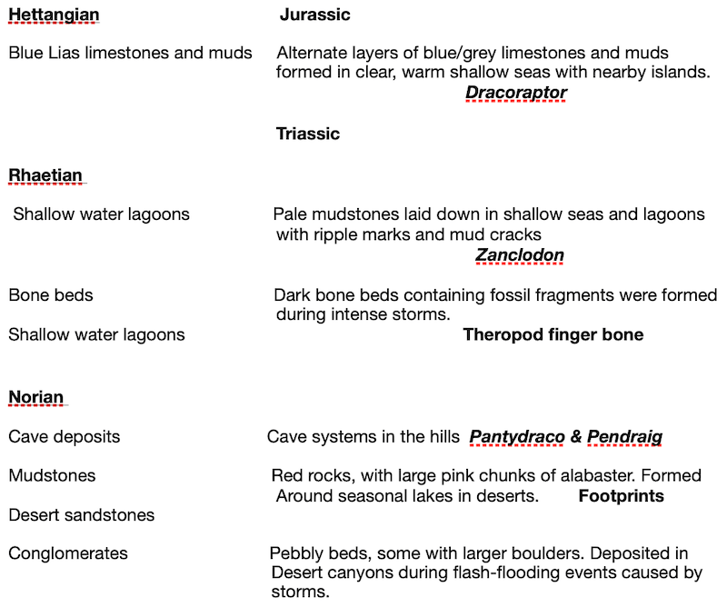
A summary can be seen in the table below:
If you would like to see fossil footprints then the SSSI site of Bendricks Bay Barry is a good site to visit. Here there have been found at least four different types of footprints.The National Museum of Wales in Cardiff also has footprints on display.
An interesting talk by Cindy Howells on the fossils that can be found in Wales.
Tuesday 19th November 2024
The October talk was by member Roy McGurn.
Summary by Roy
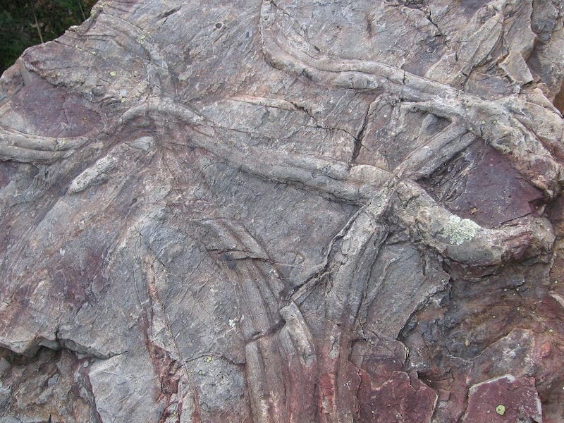
The talk was inspired by a field trip led by Tony Crimes, a leading trilobite expert in 1970 to the Nant Ffrancon valley. In particular Tony was a leading specialist in trilobite tracks, commonly attributed the ichno-genus Cruziana, amongst others.
Cruziana,Vale do Pônsul, Penha Garcia, Portugal by Correia PM Wiki Commons
Until this time trace fossils had been more of a curiosity, as mainstream fossils were more useful for dating, still very much an objective in geological research. Trace fossils are usually found quite separate to body fossils, so correlating the two is difficult, as different modes of preservation are at play.
A trace fossil may have more than one causal animal, Cruziana has been identified in the Triassic, long after trilobites became extinct. One animal may also be responsible for several trace fossils, depending on it's behaviour.
What trace fossils tell us is how the animal behaved, culminating in the stunning walking with dinosaurs films. In this instance Tony was able to say what a trilobite was doing - resting, starting or finishing swimming or feeding and burrowing. How they moved and the prevalence of juveniles etc in the population. It is assumed, for example, that juveniles were pelagic.
That year Tony had chaired an international conference on trace fossils with a Prof Seilacher of Tubingen under the auspices of the Liverpool Geological Society. Together with Richard Fortey possibly the modern triumvirate of trilobite men.
The main sites are 2000 ft up the sides of Cwm Cuenant, a daunting field trip today probably classifying as a rock climbers "scramble" or worse. However a "debris" field behind a cottage, Ty Newydd, can be quite productive of actual fossils.