Thursday 22nd August 2019
Summary of Chris Simpson’s talk, 21st August 2019:INTRODUCTION TO THE AEGEAN ISLAND ARC
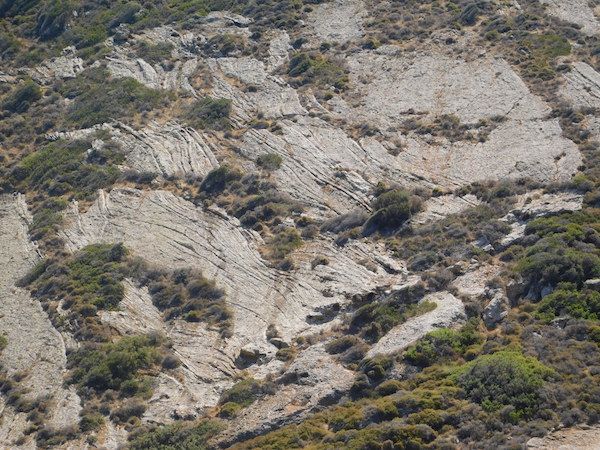
The talk was based on a walking holiday in September 2018 involving several different islands: Milos, Kimolos, Sifnos, Serifos and Santorini – all part of the Cyclades group of islands in the Eastern Mediterranean.
There is an excellent geological museum on Milos which has good specimens and a description of the geological history of these islands.
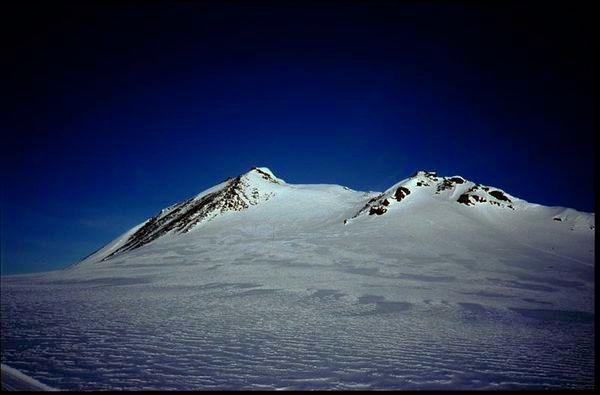
Milos belongs to the Southern Aegean volcanic arc. Its creation began 3.5M years ago with the onset of volcanic activity when the African plate subducted under the Eurasian plate. The first phase started in shallow seas and formed pyroclastic rock (ignimbrite, tuff, pumice etc.) during the middle Pliocene.
The second phase, 3M years ago, was land-based volcanic activity yielding andesitic lava. From 1.8M years ago until about 90,000 years ago, extrusive volcanic activity produced rhyolite, rhyodacite and obsidian, followed by thick layers of pumice and fine ash. Milos is still considered to be potentially active.
Milos and Santorini are both old volcanos. The other islands are the tips of submerged mountains.
Chris went through the wide variety of igneous rocks seen on the various islands.
Pahoehoe-type lava flow
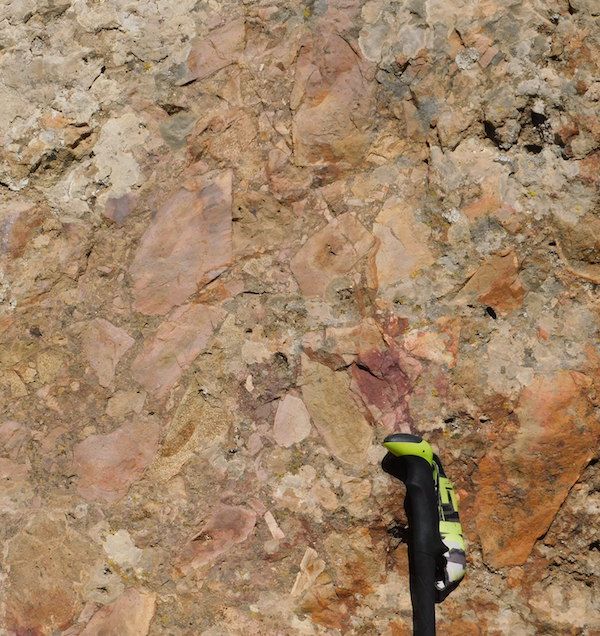
Volcanic breccia – top of walking pole is the scale
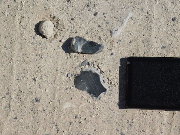
Some of the thousands of pieces of dark obsidian lying on the ground
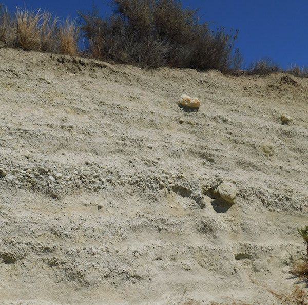
A thick layer of white volcanic ash with occasional much larger ejecta
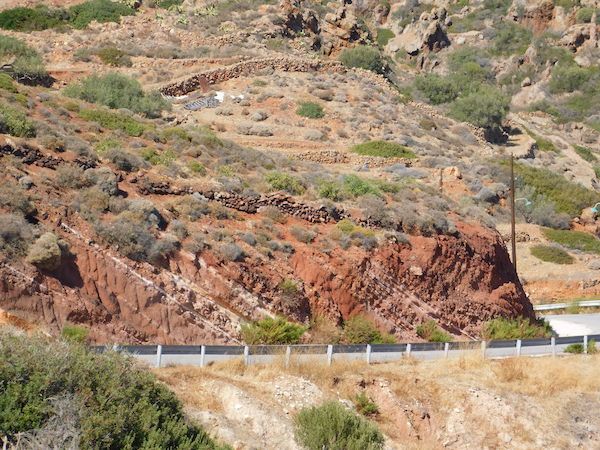
A road cutting showing a succession of volcanic ash layers. Each layer is fairly uniform; but there is variation in composition between different layers shown by the marked variation in colour
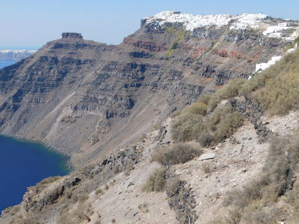
Successive lava flows on Santorini
A higher power view with obvious columnar jointing and colour change reflecting the variation in chemical composition of successive flows
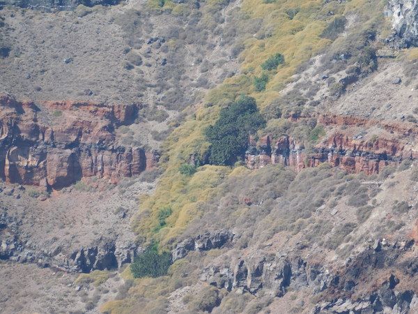
Although most of the islands are composed of igneous rocks, some areas of sedimentary rock are seen, and an occasional focus of metamorphism.
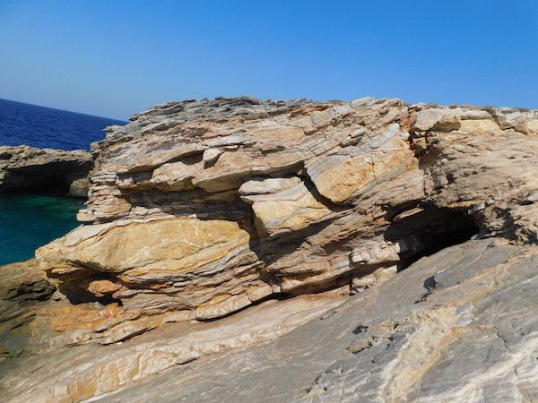
Sedimentary beds by the sea shore
Wednesday 31st July 2019
The Geology of Lanzarote
At our July indoor meeting, Prof. Cynthia Burek gave a talk on "The Geology of Lanzarote."
She is Professor of Geoconservation at the University of Chester; indeed, as far as we know, the only professor of geoconservation! She is a long time friend of our club, having talked to us on several occasions, the last of which was two years ago when she told us about "Geoconservation and the Saltscape Project", outlining conservation of the Cheshire salt industry. Our July talk took us further afield.
Lanzarote is the northernmost and easternmost of the Canary Islands which all have a volcanic origin the details of which are not at all clear-cut.
Lanzarote and Fuerteventura by map of the canary islands.svg:Mysid, Wiki Commons
Lanzarote and its geologically similar neighbour, Fuertaventura, are the oldest, having some 20Ma of volcanics exposed above sea level. They are separated by a shallow sea and would have been joined together in the Ice Age. Lanzarote has an area of some 300 sq. miles, is just 120 miles off the African coast, has no surface water and has a resident population of 146 000.
It is dominated by two shield volcanoes, Ajaches in the south and Famara in the north which are 20Ma and 10Ma old, lying on ocean basement 50-40Ma. They were originally two separate island volcanoes which were subsequently connected by products from a central rift. They are now much eroded into cliffs and ravines, with the lowlands in between having aeolean sand dunes. Surprisingly, these comprise white sand, not black as would be expected from the surrounding dark basaltic rocks. Hence there is some conjecture about their derivation. A possible source would be from the Sahara, but it seems more likely that they were formed by trade wind drift of sedimentary deposits previously exposed in periods of lower sea level.
There have been two major recent eruptions in the Holocene/Anthropocene, one from 1730 to 1736 and a smaller one in 1824.
The 1730 eruption of Timanfaya was the third largest basaltic fissure eruption of historical times, after Laki (1783AD) and Ejdgja (934AD) in Iceland. It lasted 68 months and produced 700 million cubic metres of lava from over 30 vents. It was the largest Canary Island eruption within the last 500 years.
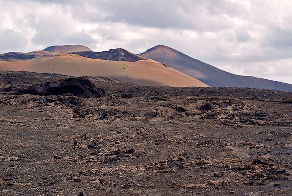
Lava field in Timanfaya photo creative commons M. Rodríguez
Fortunately reconstruction of the event is helped because there were accounts by eye witnesses, in particular by the parish priest of Yaiza. More recent smaller eruptions have produced a number of craters around the main shield volcanoes.
The 1824 eruption was smaller, lasted three months and was focussed on the Nuevo del Fuego vent in Timanfaya.
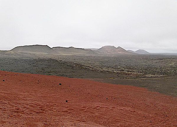
Montano del Fuego Timanfaya national park by Norbert Nagel Germany Wiki Commons
Lanzarote's wide central plain is non volcanic and covered by white aeolean sands. It is thought that some 7-5Ma during a period of low sea level the island was covered by biocalcarenite sands including terrestrial gastropods, tortoises and the eggshells of large birds together with fragments of marine fossils and volcanic clasts. Lime dissolved from these shells helped form thick calcretes on top.
There is some controversy over how the islands were formed, it could have been to do with African tectonics as part of the Atlas lineament, or perhaps above a hotspot? The islands are near a zone of Alpine deformation and could be an extension of the Agadir Fault, but no geological or geophysical evidence has been found. Nor does it appear to look like a hotspot because the time/distance relationship looks wrong. If it were moving over a hotspot, like Hawaii, the older islands, like Lanzarote, would be over cooler mantle and would have subsided by now.
A more likely scenario is that it is on a leaky transform fault, like Iceland. In this situation, in addition to the strike-slip motion, there is some extensional movement tending to open the fault, allowing melt to leak through, producing new crust.
The most influencial geologists to study the island were Juan Carlos Carracedo who worked for 40 years and published some 200 articles and Valentin R. Troll.
Perhaps the island's most famous inhabitant was Cesar Manrique, a Spanish artist, sculptor, architect and activist who lived there. He prodused sculptures which grace public spaces and left his extraordinary house, built within the volcano, to the Cesar Manriques Foundation. He influenced planning policy which strictly opposes high rise concrete. He died in a car accident in 1992 aged 73.
Strangely, for an island with no surface water, viticulture is a major industry, with vines cultivated on the rich volcanic soil and watered from condensed dew. Because of the large diurnal temperature variation, condensation occurs on stone protective walls erected round each vine.
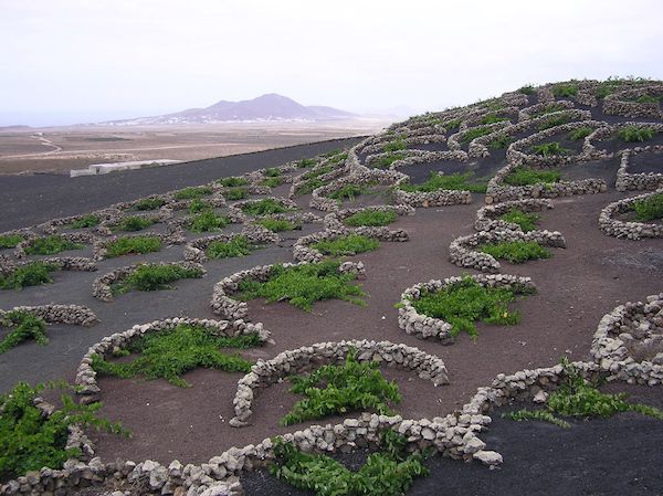
Vineyards in La Geria, photo creative commons
The area has been declared a Global Biosphere Reserve, containing the Timanfaya National Park, two nature parks, reserves, and SSSIs. Together with the island of Chinijo, it is part of a UNESCO Global Geopark which comprises a significant territory with a heritage and supporting programme. It involves geotourism, engages the local inhabitants and also fosters experiment and research to enhance its geological heritage. The locals have apparently taken "ownership" of the project and assist by policing the concept.
Altogether it was an interesting evening, perhaps inspiring some of us to visit and explore the island; "flygskam" permitting of course!
Thursday 16th May 2019
At the last meeting Prof. Neil Glasser gave a highly informative talk on the MAGIC-DML project ( of which he is part) which is a collaborative project between Sweden,UK, US, Norway and Germany and is researching the glacial history of the Antarctic ice-sheet and how it has changed over time. The area chosen for the research is Dronning Maud Land (DML) area of Antarctica which is largely covered by the East Antarctic ice-sheet. There were two field seasons in 2017 and 2018 with Prof. Glasser attending in 2017.
The ice in Antarctica is very thick ( with a mean of 2.16km and a maximum of 4.7km) such that only the peaks of the highest mountains protrude through the ice. These areas are known as nunataks. Ninety per cent of the world's ice (29 million cubic km) and approximately 80 per cent of its fresh water, is locked up in the Antarctic ice sheet. If all the ice were to melt, the level of the world's oceans would rise by nearly 60 m.
Nunatak Antartica - creative commons
MAGIC-DML stands for Mapping, Measuring, Modelling Antarctic Geomorphology and Ice-elevation Change in Dronning Maud Land (DML). (Queen Maud Land is a c. 2.7 million square kilometre region of Antarctica claimed as a dependent territory by Norway.)
Mapping- Firstly the area has to be mapped and this is done using methods such as the Geographic Information System (GIS) and Google Earth. This allows the researchers to understand the landforms they are going to survey.
Measuring - Involves using Cosmogenic nuclide testing to determine how long the surface of the rock has been exposed. This helps in determine past ice-sheet extent and the rate of recession.
Cosmogenic particles are produced when elements are bombarded by high energy particles ( cosmic radiation) that enter the atmosphere from outer space. These particles can interact with silica and oxygen in quartz ( in a process known as spallation) to produce isotopes of 6Be and 26Al. Other isotopes produced are 36Cl, 14C, 21Ne, and 3He. Thus the assumption is made that there is a constant rate of production so that the the accumulation in the rock is proportional to the length of time exposed and the rate of decay of the isotopes. The isotopes are measured using an accelerator mass spectrometer.
Samples can only be taken from the top of the rock exposure as the high energy particles cannot penetrate into the depths of the rock and any disturbance to the rock from weathering could affect the results. So the field worker has to be very careful in choosing the correct sample.
Modelling - The aim is to produce numerical models of past ice-sheet behaviour which can help predict what might happen in the future.
Next month will be the evening field trip which this year is to Middletown quarry. This will be on Wednesday 19th June 6-8pm.
Friday 26th April 2019
At the last meeting David Lockett gave a very interesting talk on the FISH ( Fossils In SHropshire project). The grant funded project commenced in 2016 with the aim of digitising geological collections at the Ludlow museum.
The museum holds in the region of 250,000 specimens which are important both nationally and internationally. Of this number there are 41,500 specimens of fossils, rocks and minerals with the greatest number being that of the fossils. The Shropshire mammoth remains found at Condover in 1986 is an example of a nationally important find.
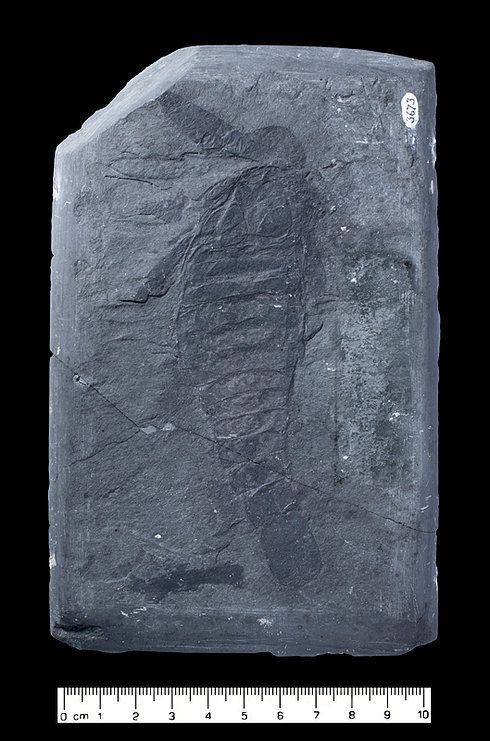
Silurian Eurypterid taken for the project
But why digitise the specimens?
- the large number of specimens cannot be physically on display.
- it allows dissipation of information.
- there are not many museums digitising their specimens
- 3D models of fossils is not really undertaken
- produces images that can be used for identification purposes
- as the collections are viewed prior to digitisation often new and unusual specimens are found.
The equipment used is based upon a 35mm DSLR camera, macro and zoom lenses, LED lighting and computer software. The 3D virtual models are obtained by photographing all sides whilst the specimen is rotated on a turntable.
They have had help from the BGS in the form of a white light scanner to scan some of the more important specimens from which a 3D model can be made.
The second half of the talk consisted of David showing images from specimens relating to each time period of the geological sequence.
The talk was extremely interesting and the images superb. If you are interested in following this project then here is a link to their website
Tuesday 16th April 2019
At our March indoor meeting on Wednesday the 20th, guest speaker, Prof. Michael Rosenbaum, gave us a talk on "Elan Valley dam construction and the Birth of Engineering Geology.”
As a result of rapid industrialisation and urbanisation of the area in the 1860s and 70s, the populace in Birmingham was largely housed in crowded tenements in insanitary conditions. Shared privies were the rule with seepage into the shallow wells owned by the water companies. The only surface water resource was the diminutive and polluted river Rea which now flows through a ditch underneath Digbeth.
Water was very short and rationed, with drinking water sold from a pony and trap. Water-borne diseases such as cholera and typhoid were rife and something had to be done to improve the health of the workforce.
The then mayor, Joseph Chamberlain, a self made man who had made his fortune as a screw manufacturer, took action. He forcibly bought up the water companies and appointed Robert Rawlinson as consultant.
Providing an adequate clean water supply was fraught with difficulty. With no adequate local river or aquifer, water would have to be found at a distance and transported. Looking at the significant rivers surrounding Birmingham, going north, the Trent was of poor quality, the Derwent required an aqueduct and pumping, in the west the Severn was too low and the Teme had too many people and high quality farms requiring compensation. The Wye was low and people in Hereford would object, so although distant, the The Elan, with the Claerwen, were selected as most suitable. They had a large catchment area with a high rainfall and enough elevation to avoid pumping.
Caban Coch Reservoir Elan Valley ( Colin Price Creative Commons)
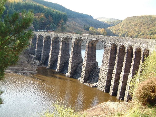
In 1890 an act of parliament was obtained and Mansergh was engaged as engineer who designed the Elan scheme with a dam at Caban Coch where the valley was constricted. Much of the local stone was called "Cyclopian" as it contained large hard cobbles and could not be accurately shaped. Accordingly, the construction of the dam was with a core of rough irregular local stone blocks, set in concrete with an Ashlar facing of accurately cut stone ferried in from a distance. This was one factor which caused a 50% cost overrun.
We were shown a remarkable 1892 photograph of Mansergh heading a group of the "great and the good" geologists and engineers on a viewing field trip. It included Prof. Topley (Surveyed the Weald), Prof. Boyd Dawkins, Thomas Hawksley (engineer for the Vyrnwy dam), perhaps showing an early merging of geology and engineering disciplines into engineering geology.
Members were treated to an interesting evening, being given an insight into the basic structure of an iconic local heritage site.
The next meeting will be on Wednesday 17th April when Daniel Lockett will give a talk on the FISH (Fossils in Shropshire) project.