Friday 7th May 2021
The April meeting of the MWGC was at 7.15 p.m. on the 21st, when Ashley Patton, Engineering Geologist, BGS Cardiff, talked on Shallow Geothermal Energy in Cities.
This was our second talk on geothermal energy. Prof. Stimpson’s was concerned with deep geothermal, where the source is primordial or from radioactivity, whereas Ashley Patton’s was on ground sources nearer the surface. Harvesting such heat can contribute towards reducing reliance on traditional, increasingly insecure, CO2-producing thermal power generation.
A heat pump works by collecting heat from one place and transferring it to another against a temperature gradient.
Its performance is often measured by the “Coefficient of performance” or COP, the amount of useful heat put into a building divided by the amount of electrical energy used. It varies from 4 or 5 under favourable conditions to not much more than 1 if the heat source is very cold. Every degree is important.
Many domestic installations gather heat from shallow coils of pipe not much more than 1m below the surface, harvesting energy ultimately derived from solar, which has been stored in the soil.
BGS Cardiff have been researching a deeper source some tens of metres below ground where, particularly in urban areas, groundwater temperatures can be elevated owing to the “subsurface urban heat island” effect This is heat which has been accumulating over long periods of time, even decades, due to leakage from basements, industry and other human activities.
To establish feasibility and enable modelling, the “Cardiff Geo-Observatory” was set up, in which 3D temperature profiles were measured in a network of boreholes penetrating the sand and gravel aquifer below the city.
A pilot open-loop ground source system was also constructed at a school which operated satisfactorily and established feasibility as to what extent temperatures are depressed when heat is extracted.
Tapping this heat source could provide a useful proportion of the space heating necessary in areas of high housing density which often coincide with the presence of shallow aquifers and urban heat islands.
The talk was much appreciated as being both topical and one which will impact all our lives in the near future!
Saturday 10th April 2021
At the last evening meeting ( March 17th via Zoom) Dr. Ian Stimpson ( Keele University) gave a very informative talk on deep geothermal energy. The aim of the talk was to help us understand the concepts of geothermal energy and how it could apply to the UK as it has the possibility to become a very green and low carbon source of energy.
Geothermal energy ( i.e. heat derived from the ground) can be divided into two main categories shallow and deep. Dr Stimpson concentrated the talk on the aspect of deep geothermal as our next talk in April ( to be given by Ashley Patton) will be of shallow geothermal.
The difference between the two is related to depth. Shallow geothermal heat is stored near the surface and is derived from external to earth sources or solar radiation with the earth acting as a solar battery. In contrast deep geothermal sources are at greater depth with the energy arising from mechanisms internal to the earth from primordial heat from when the earth was formed and radioactive decay of long-lived isotopes of uranium, thorium and potassium.
There are advantages to using geothermal as firstly, it is not affected by the weather and can therefore run for 24 hours per day. Secondly, the surface area of the plant is the smallest of any power source and as the buildings are not high there is little visual impact. It has been predicted that it could provide up to 20% of Uk’s energy needs.
But where are the best places for geothermal energy projects. This can be determined by observing the heat flow through the crust. It has been found that large areas of the crust have about the same heat flow with an average of 60mW m-2. The areas in the world where heat flow is much greater are found close to active plate margins below the ocean. Values on the continents can be as high as 300 mW m-2 where magma is being generated locally.
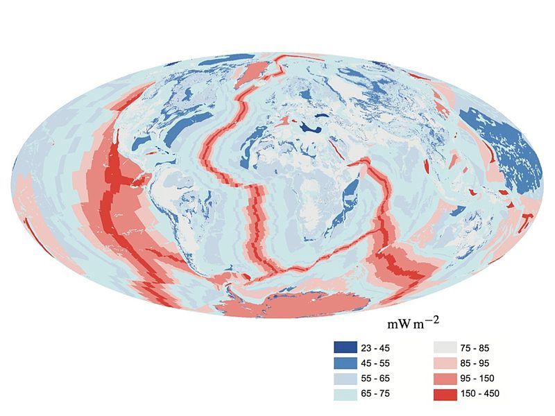
Global Heat Flow- wiki commons Davies and Davies
For a geothermal system there are 3 requirements: heat, water and permeability. So one means of obtaining the energy is to drill down into the natural ground water in a deep aquifer. Two wells are bored one for abstracting the hot water and the other for returning the cold water to the ground. But often permeability or water may be a problem so that new enhanced geothermal systems ( EDS) have been or are being developed.
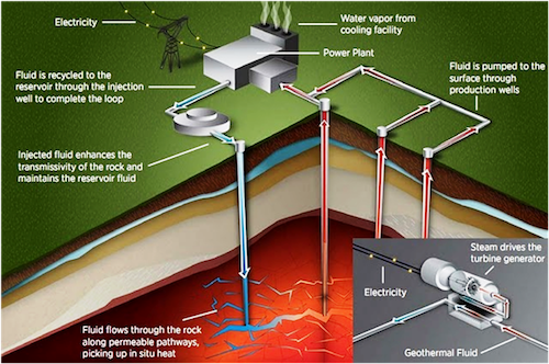
Geothermal Energy Tapping - wiki Commons Energy.gov
One EDS is the hot dry rock system (HDR). The target rock being granite as it is rich in uranium, thorium and potassium. This requires the rock to be artificially fractured. Cold water is pumped down the injection well to produce a network of tiny fractures in the rock which creates a pathway through the rock along which water can flow. Water is heated up and the super-heated water is taken back to the surface via another well. Although it is a difficult method it is one that can be used in areas, for example the UK, away from active plate margins where the highest energies are present. There was an early research project into HDR system at Rosemanowes Quarry Cornwall during the 1980s. Data and knowledge gained from this project have been used for the new United Downs Deep Geothermal Project (UDDGP) in Cornwall. This project, instead of fracking the granite, will use naturally fractured rock around the Porthtowan Fault zone.
A further idea for obtaining energy is to use super critical CO2 to release the energy.Known as ECO2G the idea is that CO2 can be cycled through hot regions kilometres underground and would bring heat to the surface, where it can be used to generate electricity.
Further, there are a new generation of closed loop systems known as advanced geothermal systems (AGS). This idea moves on from using fracking and there are no fluids either put into the ground or extracted. Instead fluids circulate underground in a network of sealed pipes, pick up the heat and take it to the surface. One of these systems is planned by Eavor, a Canadian company. It’s system has two vertical wells 1.5 miles apart and connected by horizontal wells. In this system fluid is pumped down a borehole and is transferred along a series of horizontal boreholes, picks up the heat energy which is then utilised. The now cooled fluid is then pumped back down along another series of boreholes in the opposite direction.
Within the UK geothermal energy appears to be playing catch-up compared to
other parts of the world. The idea was investigated during the 1970’s but with North Sea gas and nuclear energy becoming cheaply available geothermal was
abandoned. With the climate crisis ever deepening green energy solutions are
urgently required.
In the UK we do not have volcanic sources of energy but do have deep saline
aquifers. These are permeable, porous rocks mainly found at depth in the
Mesozoic basins ( Permo-Triassic sandstones) For example the Cheshire basin
where the resources are concentrated in the south east of the basin against the main bounding fault at Crewe.
The first geothermal power plant based on a deep saline aquifer was in
Southhampton in 1981 utilising the rocks in the Wessex Basin. It still produces energy today.
The Uk also has areas of granite in south west England, the Lake District and
Scotland that could be suitable for HDR and the first one in Cornwall is due to be opened.
Monday 22nd February 2021
At our last meeting Scott Bennett gave an inspiring talk entitled “Climate Change, Mass Extinctions and the Age of Homo sapiens”
The aim of the talk was to try and observe on a geological time scale the significance of the effects of humans. He was to argue that human civilisation is now at a crossroads.
There have been five mass extinction events in the past when a large percentage of life disappeared completely. Knowledge gained from the study of these events has led to the following insights:
- Speed and/or magnitude of an event and complexity of a life-form all contribute to vulnerability to extinction.
- The worst extinction events usually have multiple triggers/ causes.
- Triggers such as asteroids and flood basalt events are merely the first step in a chain reaction of cataclysms that drive major extinction events.
- A change in the earth’s carbon cycle, greenhouse effect and global temperature are a key feature of every major extinction event
- Climate and chemistry cycles on earth will take millennia to find a new equilibrium after such events whilst biodiversity can take millions of years to recover.
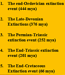
Five mass extiction events
These extinctions were all caused by natural events but the sixth mass extinction, which is now under way, is being caused by a biological force which is human civilisation. The rise of Homo sapiens was gradual but with the onset of the Holocene and stability of the climate came the first changes as agriculture was born. Civilisations began to be developed and eventually began the road to where we are now. With the industrial revolution mechanisation transformed the way of work. Health and nutrition improved, housing improved as did modern medicines. The death rate declined and the population increased markedly, such that the world population at 900 million in 1800 had reached 7.7 billion by 2019.
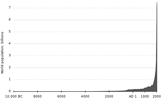
World human population (est.) 10,000 BC–2000 AD by El T Wiki Commons
Our human civilisation is hurtling out of control. Wealth, for some parts of the world, has increased vastly which requires vast amounts of natural resources. So much so that in 2019 we extracted 105 billion tonnes of natural/mineral materials. This rate cannot continue as to do so we would require 1.6 earths to meet our needs. We extract far too much , we disrupt the surface of the planet, add pesticides, herbicides, fungicides and fertiliser to the land all of which is altering the chemistry of land, air and water. It has been estimated that world-wide the deliberate annual shift of sediments by humans is 57,000 million tonnes which is about three times that of rivers and oceans. so humans are a geological force.
We are thus having a marked effect on the only planet we have to inhabit. Atmospheric carbon dioxide levels have increased from 280ppm in 1880 to 415ppm now and has not been this high for millions of years. Related to the increase in CO2 is an increase in ocean acidity which can have an effect on those organisms with hard shells. Due to the greenhouse effect of CO2 global temperature has increased by 1.02C since 1880 with the 19 hottest years occurring since 2000.
In addition to our effects on the carbon cycle we are also having an effect on the nitrogen cycle. Humankind’s increasing use of reactive nitrogen in fertilisers, plastics, explosives, among many other products, leads to problems as most of the nitrogen is leaked back into the environment. This has many and varied effects with high costs to the environment, people and in monetary terms.
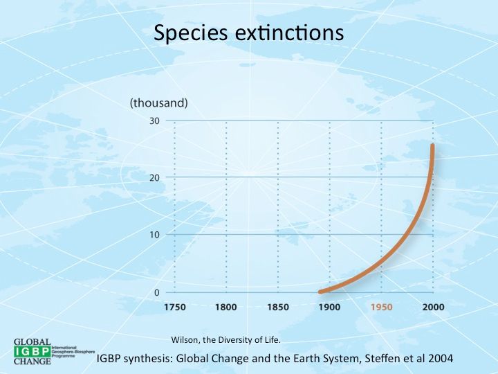
Species extinctions by Owen Gaffney IGBP synthesis: Global Change and the Earth System Wiki Commons
So what can be done about the effects we humans are having on the environment? The worst case scenario can be avoided but it will take effort and will be expensive but the alternative cannot be allowed to happen. Therefore the following are ways in which catastrophe may be averted:
- The earth must not exceed 1.5C above pre-industrial levels
- We must reach net zero CO2 emissions before we use up the carbon budget
- Global emissions must decrease by 45% by 2030
- Net zero emissions must be reached by 2050
- Possibly will need to maintain negative carbon emissions for the rest of the century.
In order to achieve these outcomes it is up to everyone from governments to the ordinary person to ensure that requirements are achieved. Business as usual cannot go on. There should be more talking about climate change in the community, in news papers, national news and at government and international levels. Pressure must be put on politicians to get to grips with the crisis and peaceful direct action is going to play it’s part.
Wednesday 25th November 2020
At our latest Zoom meeting ( November 18th) John Mason gave a well-illustrated talk entitled Extraordinary preservation of original textures in some early Ordovician intrusive rocks of the Mawddach Valley, Coed y Brenin, North Wales.
The area around Coed-y-Brenin is geologically complex. The rocks are sedimentary, Middle to Upper Cambrian in age, are intruded by intermediate to basic igneous rocks of late Cambrian to Lower Ordovician and are uncomformably overlain by the Lower Ordovician Rhobell Volcanics.
The area, once grazed lands, was planted with dense conifer forests from 1920 onwards causing rock exposures to become hidden.This makes geological mapping difficult although cuttings alongside forestry roads do allow for some work to be undertaken. Since the mid-1990’s John has worked in the area undertaking mapping and geochemical analysis. Along with Natural Resources Wales he set up the “Volcano Trail” in early 2000’s. In recent years, John has been doing further detailed mapping of the area, both by himself and in conjunction with students working on collaborative projects.
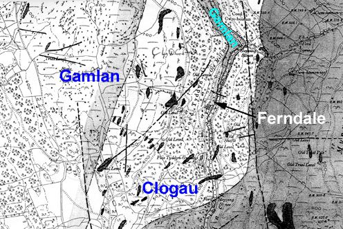
Part of a map dated 1907, by A. R. Andrew, annotated by John Mason. This map was prepared some decades prior to the purchase of the land by the government and its extensive afforestation. Of the extant maps, it is the closest to what is present on the ground, although he did not differentiate between intrusive rock-types. He likely had the best mapping-conditions of anyone who has examined this ground, since much of it was hilly pasture at the time.
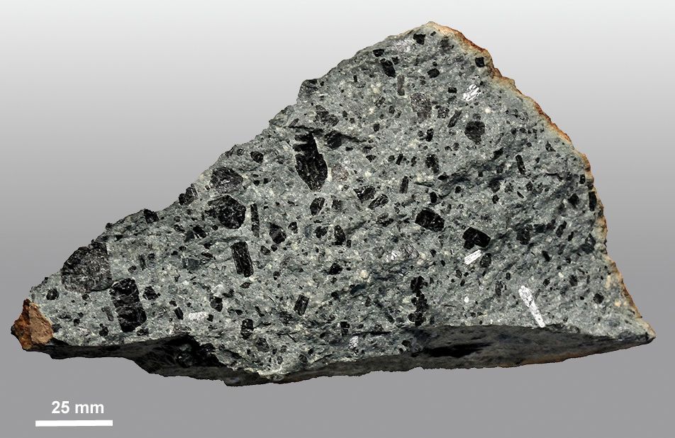
The Northern Porphyry, which occurs as a cluster of angular boulders in excavations in glacial drift in the north of the area examined. Very similar to the Magnificent Uralite Porphyry, but perhaps with even more spectacular hornblende phenocrysts, the parent body remains unlocated, in an area with very poor exposure and dense conifers. Yet the angularity suggests the source is not far away.
Using superb photos of samples/ thin sections of the intrusive rocks John took us through the various Rhobell-related intrusive igneous rocks of the area which describes a classic sequence found in fractionating magma chambers of island arcs. Rocks becoming increasingly siliceous over time. This is nicely shown in the discrimination plot below. One outlier to this sequence was the sample CTG 32 and is probably related to the Aran Volcanic Group with an ocean floor basalt geochemical signature.
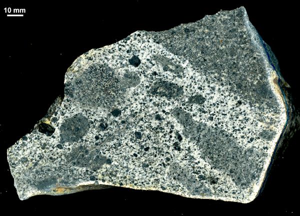
cut and polished section from Daren Wyddan, showing angular cognate blocks of hornblende-gabbro in a matrix of leucocratic microdiorite. Daren Wyddan is a large composite intrusion. The gabbro was intruded by the microdiorite; the latter contains a remarkable inclusion-population including cognate cumulate blocks consisting largely of hornblende and reaching several centimetres in size - in this specimen they are the smaller jet-black areas. These are the first such blocks to be described from intrusives here.
Many of the igneous intrusions have undergone intense hydrothermal alteration often having a grey-green colour and are known locally as “Greenstones”, but there are also unaltered rocks present. Using samples form both rock types it is possible to look at what happens geochemically to a rock when it becomes altered.
John went on to show us the results of various geochemical analyses on some of the intrusive rocks, both altered and unaltered. On one least altered rock sample the plot had a trend which would be expected in a fractionation sequence but it’s altered form showed no such trend.
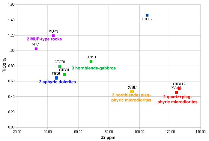
A discrimination diagram plotting TiO2 against Zr for the least-altered Rhobell-related intrusive rocks, which show a progressive increase in Zr with ongoing magma-fractionation, a typical island arc progression with island arc tholeiites early in the sequence trending to more calc-alkaline compositions with time. CTG32 is an obvious outlier - in all plots - and examination of data from other studies indicates it to be probably related to the Aran Volcanic Group, with an ocean-floor basalt geochemical signature. There are other outlier intrusives elsewhere in the Harlech Dome, especially among the dykes, some of which are cleaved but others not. A detailed study is required in order to sort this out: that a probable Cenozoic basalt dyke has been found in Coed y Brenin suggests members of this relatively young suite may also be present elsewhere. At least three phases of igneous activity are represented within the greater area
Another example was of the Magnificent Uralite Porphyry which showed that in it’s altered form some elements remained stable but there had been a decrease in calcium, sodium and phosphorus and an increase in potassium. This was also related to changes in the trace elements in that there was an increase in rubidium ( related to potassium) and a decrease in strontium ( related to sodium).It also appeared that the altered rock had the heavy rare earths stripped out.
This was a most interesting talk and took us into a field we rarely delve into.
Tuesday 10th November 2020
Last month's zoom meeting ( October) John Mason had to cancel his talk on "Coed y Brenin" and we fell back on a more participative format for our meeting, which was quite refreshing and more in the spirit of the club.
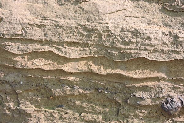
We had lots to talk about, in particular, our September trip ( following Corvid guide to six participants) to Tonfanau. Both Bill Bagley and Chris Simpson had taken lots of photographs and Chris had prepared and gave a presentation, with comments and contributions from the other members. For our members who live inland on top of a post glacial landscape, where sections quickly become vegetated, Tonfanau offered a rare chance to see features in an extensive clean vertical section.
The section is accessed through a gate at the southern end of the section, near the site of a borehole which showed some 36m of Quaternary till and gravel, on Tertiary deposits, with Cambro-Ordovician sands and siltstones at 71m. So we were seeing a thin section above a thick pile of glacial deposits.
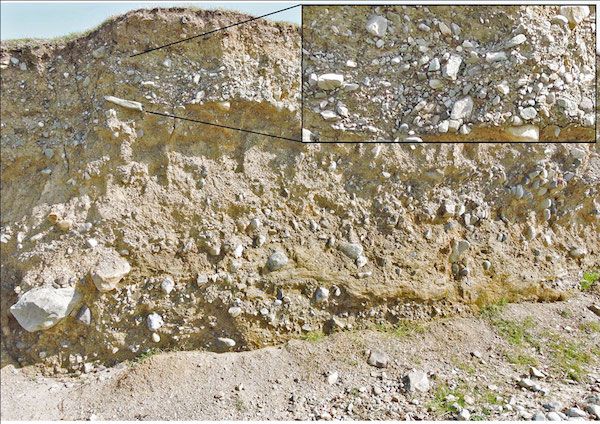
South section deposits
The cliffs here comprise 2-3m of a massive beige-brown till containing clasts from pebble to boulder size, ranging from angular to rounded, with some being facetted. The spit test shows it to be quite sandy. Provenance of the clasts has shown them to have come from the north, so this is a lodgement till from the Irish Sea Ice stream. (That is debris carried along at the base of the glacier and deposited without being washed out and sorted with the meltwater.) As some of the clasts are well rounded, there must have been water involved in their history at some time, but they have come a long way and could have a complex past.
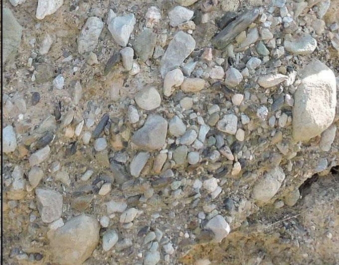
Channel fill deposits
Walking further north, we found Welsh ice protruding at the foot of the cliffs, below the Irish. It was a darker green-grey and was (spit) more clayey. It is interesting that, although clay particles stay suspended longer than sand, once deposited and indurated, they are more resistant to wave erosion and therefore project further onto the beach. On this coastline, at different times, either the Irish or the Welsh Ice, from the hills to the east, must have become dominant.
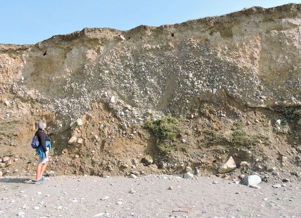
Possible cryoturbation structure
As we went further on, the cliffs got higher, up to 4 metres, and more interesting. We were getting gravel beds of pebble to cobble-sized clasts with little matrix. These must have been transported by very fast flowing water as outwash or esker discharges from the melting glacier. Many of these were broken up as the section cut meandering or braiding outwash channels which were also broken up by ice movement. Thinly laminated silts and sands were also appearing with the occasional lone stone which appeared to be a "dropstone" i.e. one released from the bottom of floating ice or an iceberg.
Current waveforms with dropstone
We were left with a vivid dynamic image of the melting snout of a glacier, with braiding outwash channels and proglacial lakes with icebergs.