At our indoor meeting on Wed 20th February, Bob Loveridge, Research Fellow in the School of Earth and Environmental Sciences at the University of Portsmouth, gave a talk on 'Flying reptiles at Buckingham Palace', including how a team of researchers did their giant pterosaur spectacular for The Royal Society's 350th Anniversary and how they took pterosaurs to meet the Queen at Buckingham Palace.
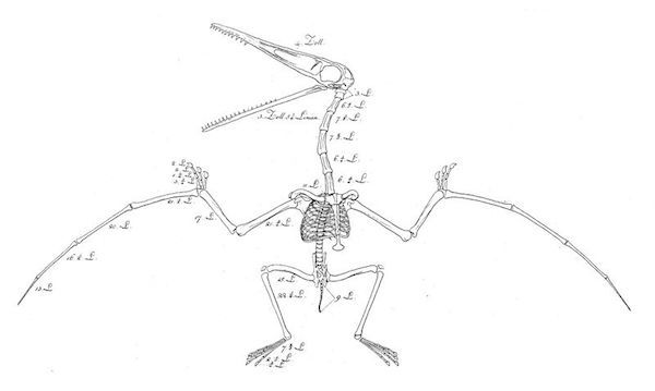
Pterosaurs were flying reptiles, best imagined as "flying crocodiles". Finds in the early 19th century were generally described as avian, including "bird bones" described by Gideon Mantell and finds by Dean William Buckland of the first UK specimen. In 1828 Mary Anning uncovered a complete specimen, albeit as a jumble of bones. It was Cuvier who first reconstructed the skeleton and recognised them as flying reptiles.
Pterosaur reconstruction Sommerring 1812 - Wiki Commons Image
They were famously popularised by Conan Doyle when he published "The Lost World" in 1912 and have remained popular ever since.
Pterosaurs evolved in the Triassic and developed into many forms from the size of small birds to the giants with enormous wings and long necks and heads in the Cretaceous. They sported bizarre head crests the purpose of which is obscure. They could have been for maintaining heat balance or for sexual display. (It is established that they had sexual dimorphism.)
The largest, Quetzalcoatlus, was some 40ft long, with a three metre neck and head, the largest ever flying animal, comparable to a Spitfire! It probably fed on small fish and there is some controversy over how they flew, but it does look as though they were capable of powered flight.
The skeletal structure was somewhat bat-like, with the skinny wings supported by an extended fourth finger. Unlike birds, on landing, they took up a quadruped position.
One recently discovered, now in the Kimmeridge Museum, is named Cuspicephalus scarfi after Gerald Scarfe due to its resemblance to Scarfe's iconic charicature of Margaret Thatcher!
As part of the celebration of the 350th anniversary of the founding of the Royal Society, the team from the University of Portsmouth built a flight of life sized flying pterosaurs which 'flew' (suspended on wires) above the Southbank Centre in London.
In addition to celebrating the founding of the oldest scientific society, it was an opportunity to learn more about how these animals flew and walked. The models were built on a lightweight frame with assistance from Griffon Hoverwork and were fabricated from foam with a hairy textile covering. The eyes comprised finials from B & Q, suitably painted.
To demonstrate the size of these animals, with help, Bob unfurled a scale drawing of one wing which went two thirds the length of the auditorium. (The whole animal would not have fitted in the room.)
The models were also exhibited at Buckingham Palace as part of the Queen's 80th birthday celebrations when they were enjoyed by her, other members of the Royal Family and by many schoolchildren invited for the occasion.
Bob was thanked for showing us models, books, drawings and fossils and giving a memorable talk with a difference.
The next meeting will be on Wednesday 20th March when Professor Michael Roenbaum wiii give a talk entitled: "The Elan Valley Aqueduct and the Birth of Engineering Geology."
Monday 28th January 2019
Twenty six members attended the AGM which was followed by a talk on Anglesey's geology based around the geology observed during the club's annual summer weekend. The weekend was led by Dr. Charlie Bendall.Below is an outline of David's talk.
The standard view of Anglesey geology, based on the detailed work of Edward Greenly in 1919, dates from long before plate tectonics was understood. There has been much controversy about the exact chronological order of the main units, and whether they might perhaps be “upside down”.
Since 2007, some Japanese scientists, working with Brian Windley of Leicester University, have put forward a new view, where the Anglesey rocks are seen as a classic example of what happens when an ocean plate is subducted under a continental plate. The main components, including an accretionary complex, extensive mélange, an exhumed blueschist, an ophiolite sequence, and continental margin sediments, are exactly what one sees in other parts of the world where an ocean plate has been subducted. An example is the San Francisco region - as was well illustrated in Chris Simpson's recent talk to our group. As Chris pointed out, one of the key features of such a scenario is that the older units are on top, with the younger units thrust underneath - the opposite of the usual stratigraphic order!
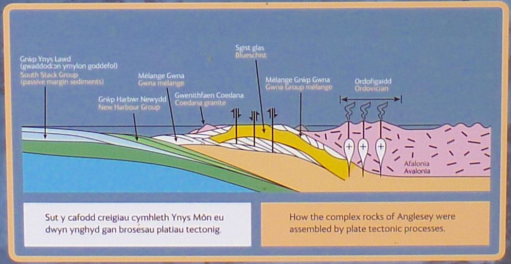
The “Japanese” analysis is summarised in the following diagram by Professor Shigenori Maruyama, taken from my photo of the GeoMôn geopark information board at Llanddwyn Island:-
GeoMôn geopark information board at Llanddwyn Island
To summarise the story, around 680Ma, an oceanic plate was being subducted under Avalonia, leading amongst other things to the magmatism of the Malvern Hills. Subduction was building up an accretionary complex corresponding to the Gwna Group. The accretionary process continued over a long period of time until at least the early Cambrian.
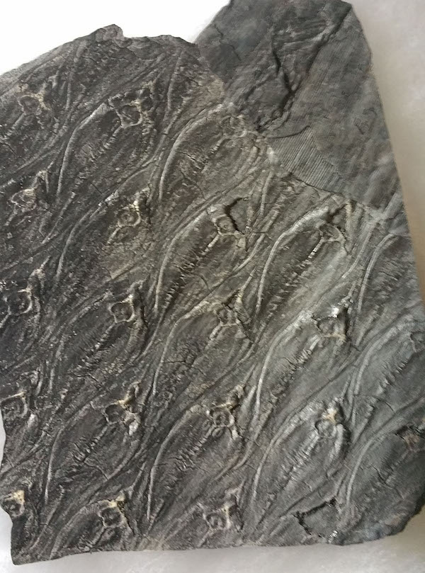
The accretionary complex mainly consists of ocean plate sediments scraped off the descending plate by the overriding continental plate. It typically comprises a succession of small units thrust one under another in succession. Each unit, or “horse”, represents a slice of seafloor. Each typically encapsulates, at the base some pillow basalt from a mid-ocean ridge, capped by bedded chert and sometimes limestone, with possibly mudstone and turbidites on top. The units are particularly well exposed over the entire Llanddwyn island, where the Japanese scientists have mapped out 23 “horses”, which they believe represent over 7,800m of seafloor shunted into an accretionary deposit only about 300m thick.
At the core of the subduction's accretionary process is a deep oceanic trench, with a particularly steep slope on the continental side. In many situations, material tumbles down this slope, creating a chaotic mixture of various rock types, mostly derived from previously accreted seafloor, with components ranging from kilometre-scale chunks down to small pebbles. This is the famous Gwna Mélange. As I understand it, it's more likely to be the result of an ongoing process, rather than being produced by a single, huge, catastrophic event. The mélange can be seen on the north coast of Anglesey, and less dramatically at the southern tip of Llanddwyn island as well as the famous example on the mainland at the southwestern tip of the Lleyn peninsula.
Gwna mélange
Returning to the detailed story of the subduction, it is thought that at around 620-600Ma or perhaps earlier, Avalonia advances to the point where a mid-ocean ridge gets subducted. Although the exact effect of such an event is unclear, it is suggested this led to the creation of the Coedana granite within the continental crust at the edge of Avalonia.
Around 575-550Ma, a ductile wedge of the accretionary complex, a few kilometres thick, gets subducted, recrystallised under blueschist conditions (high pressure but relatively low temperature), and then is squeezed back to a higher level, possibly assisted by a shallowing subduction angle. In this way, the Blueschist Unit is formed.
After the emplacement of the Blueschist Unit, the accretionary process continues, with conditions producing mélange becoming more prevalent.
During the final stages of the subduction, in the Cambrian, continental margin sediments corresponding to the New Harbour Group, and subsequently the South Stack Group, are underthrust more-or-less intact into the base of the accretionary complex. This underthrusting leads to doming of the already accreted complex, causing a fragment of the western margin of Avalonia containing the Coedana granite to become separated from the rest.
At some point after the New Harbour Group turbidites were emplaced, a deep slice of ocean crust was thrust within it - as a so-called “dismembered ophiolite”.
After subduction had largely ceased, magmatism continued into the Ordovician, resulting in the igneous rocks of North Wales. And there the subduction story ends.
In a later paper from 2013, Windley and others show that the Anglesey story is far from unique. For at least 3.8 billion years, the Earth has experienced a remarkably consistent process of sea floor spreading, subduction and accretion at continental margins. Other examples are to be found in Greenland, Central Asia, Japan, and the previously mentioned California coastal range. A further example is nearer at home in the southern uplands of Scotland, where an accretionary complex was formed on the margin of Laurentia as the Iapetus Ocean was being subducted. All of these examples show very similar rock types and structures. It appears that the overall process is a major factor in the creation of continental crust. It is even suggested it has played a part in plate tectonics being a major heat loss mechanism on Earth since the early Precambrian.
Friday 7th December 2018
Twenty members attended the November evening during which Chris Simpson presented a short talk related to two geological sites of interest he had recently visited in Catalonia.
The talk was followed by a presentation to Colin Humphrey and his wife Mary as they are moving down to Hampshire. Colin has been a driving force behind the club for the last sixteen years and we wish them both all the best for the future.
Summary of talk:
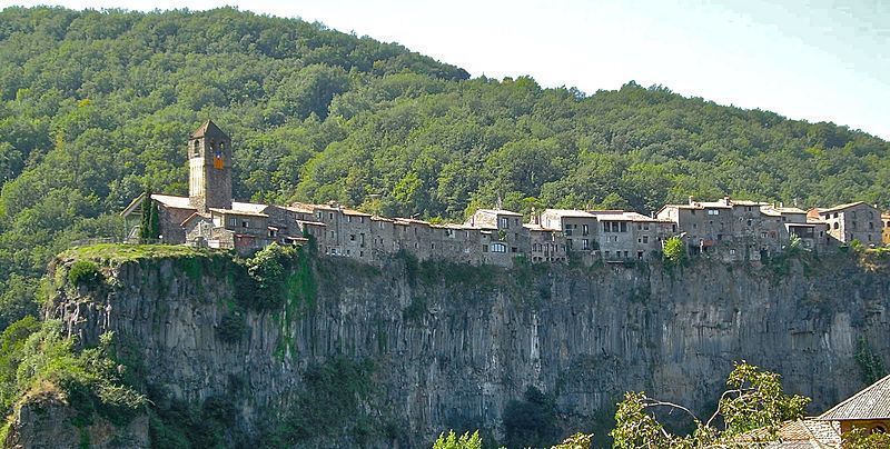
Castellfollit de la Roca This is situated in Northern Catalonia about 50 – 60 miles South of the Pyrenees and is one of the eleven townships which compose the Garrotxa Volcanic Area Natural Park. Two rivers ( rivers Fluviá and Turonell) merge into one, and there is a narrow triangle of land between the two where they merge. Over a long period of time, the two rivers have eroded down, leaving the triangle of land standing out as a 50m high feature with sheer sides facing the two rivers. A medieval town was built on this land, presumably because it was so easy to defend from any attackers. The 50m high cliffs show beautifully the two lava flows with obvious columnar jointing within each flow. The lava flows have been dated, the first with a date of 217000 ± 35000 and the second at 192000 ± 25000
Castellfollit de la Roca Creative Commons by Chensiyuan
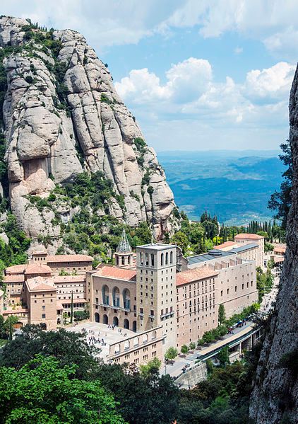
Montserrat is the highest mountain in a chain situated about 50miles West of Barcelona. It is 1,236m high and has a distinctive saw-toothed appearance which gives it its name. It is largely composed of conglomerates which were deposited in the Eocene era as a large fan delta. The clasts are mostly limestone and cemented with calcite. Montserrat began its formation due to the upthrusting of the Catalan Coastal Range. Denudation of this new mountain range front produced the fan delta conglomerate at its base. This sequence was about 1300m thick. During the Upper Oligocine to Lower Miocine there was an extensional phase of the Iberian peninsula causing the massif to rise, which led to the development of joints. Now the massif was also exposed to the elements leading to differential erosion and the development of a karst landscape seen today.
The Next meeting will be the AGM on Wednesday 16th January 2019. This will be followed by a short talk by member David Warren entitled: " The Geology of Anglesey."
Montserrat - creative Commons by Jordi Domenech
Saturday 22nd September 2018
Indoor meeting on Wednesday 19th September
"Fossil Plants of the Carboniferous Period: a personnel collector’s perspective." Paul Lane.
Paul gave an outline of his history and how he became interested in fossils. His grandfather came to South Wales in 1910 from a rural background to work in the pits and his father followed him into the mines. Paul started collecting fossils when he was about 9-10 years old most being collected from the tips around where he lived in the Rhondda Valley. His father made him a “pick” and gave him an old gas mask bag to hold the specimens.
When at school a new teacher arrived from Aberystwyth who offered geology as a subject and therefore he could study geology at ‘O’ and ‘A’ level after which he undertook a teaching degree with geology as the main subject and the rest (as he states) is history.
Paul then proceeded to describe the Carboniferous Period and the plants that occurred:
Around 359 Ma, at the start of the Period, Great Britain was lying at the equator, covered by the warm shallow waters of the Rheic Ocean, during which time the Carboniferous Limestone was deposited, as found in the Mendip Hills, North and South Wales, in the Peak District of North Lancashire, the Northern Pennines and Southeast Scotland.
These were followed by dark marine shales, siltstones and coarse sandstones of the Millstone Grit. Later, river deltas formed and the sediments deposited were colonised by swamps and rain forest. It was in this environment that the cyclic Coal Measures were formed, the source of the majority of Great Britain's extensive coal reserves that powered the Industrial Revolution.
Lepidodendron by Paul
Average global temperatures in the Early Carboniferous Period were high: approximately 20°C (68°F). However, cooling during the Middle Carboniferous reduced average global temperatures to about 12°C (54°F). Lack of growth rings of fossilised trees suggest a lack of seasons of a tropical climate.
Glaciations in Gondwana triggered by Gondwana's southward movement, continued into the Permian.
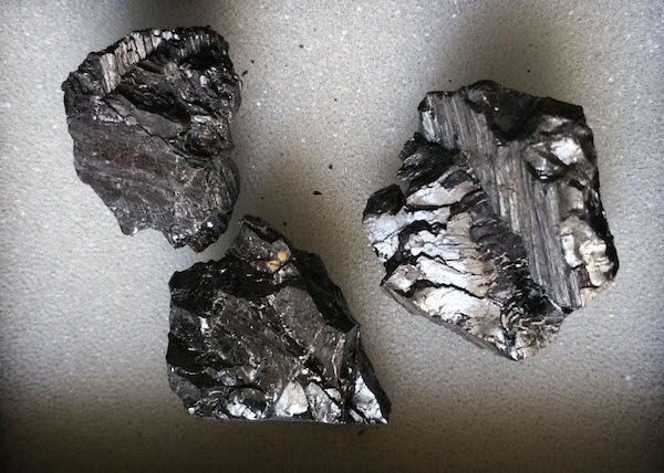
3 pieces of coal by Paul
The thicker atmosphere and stronger Coriolis Effect due to earth's faster rotation (a day lasted for 22.4 hours in early Carboniferous) created significantly stronger winds than today.
The cooling and drying of the climate led to the Carboniferous Rainforest Collapse (CRC) during the late Carboniferous. Vast tropical rainforests collapsed suddenly as the climate changed from hot and humid to cool and arid. This was likely caused by intense glaciation and a drop in sea levels.
At the next meeting Kit Moorhouse will give a talk entitled: “North Sea Oil Fields and Debris Flows”
Monday 27th August 2018
Evening meeting Wednesday 15th August 2018- Overview of the Geology of San Francisco - Dr.Chris Simpson
The geology of the San Francisco area is complex, and is related to tectonic events over the last 200M years. Today, the North American plate lies next to the Pacific plate. 200M years ago, however, there was another plate composed of oceanic crust lying between these two – the Farallon Plate – named after the Farallon Islands which lie off the West Coast of the USA and are on a small remnant of the Farallon plate. Most of the Farallon plate has now disappeared, having been subducted under the North American plate.
The Juan de Fuca micro-plate and the Rivera micro-plate are surviving remnants of the original Farallon plate.
30M years ago, the subduction of the Farallon plate was finishing, and the Pacific plate was coming into direct contact the North American plate. At this time, the subduction process ended, and the Pacific plate started sliding Northwards along the edge of the North American plate. This transform faulting created the San Andreas Fault system which extends for hundreds of miles up and down the West coast of the USA. Movement along the San Andreas fault created the San Francisco earthquake in 1906.
Point Reyes is a promontory projecting West into the Pacific Ocean about 30 miles North of San Francisco. The relief map above shows the line of the San Andreas fault very clearly as a diagonal line heading roughly NNW – SSE. The line of the fault is marked by inlets of the sea such as the Tomales Bay. Between these inlets, the fault line is low-lying, often marshy land.
All the land West of the fault line lies on the Pacific plate. Careful correlation of the rock formations on both sides of the fault has shown that the Pacific plate has moved hundreds of miles North relative to the North American plate since the formation of the San Andreas Fault. The rocks which make up the actual point – the Point Reyes Conglomerate – match an identical area of rock near the Monterey Peninsula, 100 miles to the South.
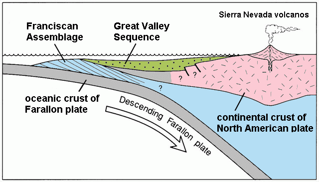
While the Farallon plate was subducting, several episodes of accretionary prism formation were occurring. Rock is accreted against the American plate instead of being subducted.
The oldest prism is the highest in the sequence – the opposite of what is seen in sedimentary beds. Between the prisms, there is concentrated movement with grinding of rock and subsequent melange formation.
Diagram showing model for emplacement of Franciscan Assemblage and deposition of Great Valley sequence 2013 Mikesclark Creative Commons
San Francisco Bedrock Today
There are five distinct layers underlying San Francisco in a sequence from East to West:
Alcatraz Sandstone
Hunters Point melange
Marin Headlands terrane
City College melange
San Bruno Mountain Sandstone
The two melanges are similar and were caused by intense shearing during the formation and subsequent exhumation of the accretionary prisms. They comprise a mixture of rock types and size ranging from large boulders hundreds of metres across to fragments <<1mm. The small fragments are easily eroded, leaving the boulders behind. This is commonly seen on the sea shore. Also, landslides and slumps are common within the areas of melange.
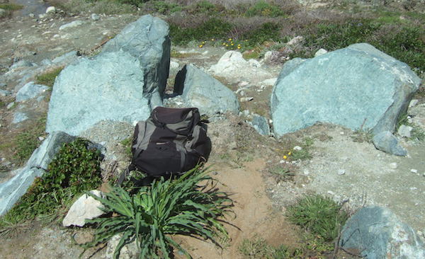
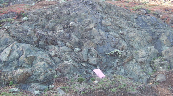
Large blocks of serpentinite in the Hunters Point Mélange. (my rucksack for scale)
The sandstone areas look similar to the naked eye, but they are very different geochemically. The Marin Headlands terrane is a patchwork of different rock types in close proximity, pillow basalt, red chert and sandstone – but not a melange.
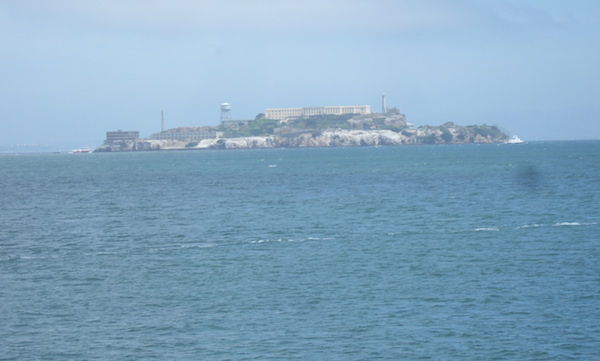
Alcatraz Island out in San Francisco Bay is composed of thick beds of Alcatraz
Sandstone
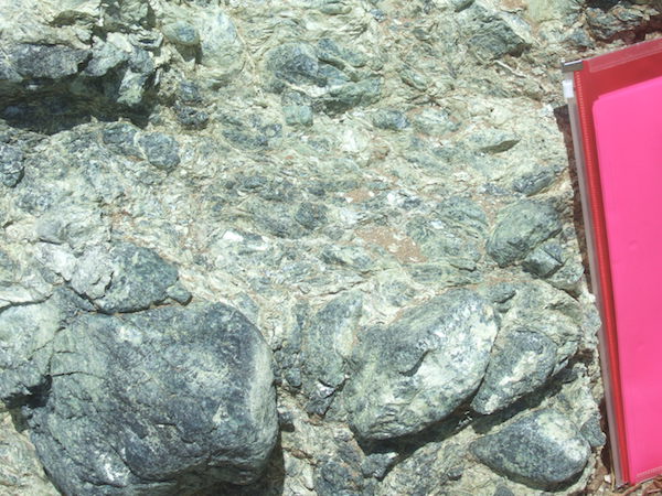
The Marin Headlands terrane containsvarious rock types including pillow lavas. A4 folder for scale
Angel Island
Further out in San Francisco Bay than Alcatraz is Angel Island. This was a military site, but nowadays it is a nature reserve and tourist attraction. Geologically, it is very interesting because most of the rocks are metamorphosed. This points to the fact that the rocks on Angel Island were buried deeper in the subduction zone than the other rocks in and around San Francisco.
The original sandstone, pillow basalt and serpentinite have become schistose sandstone, schists, blueschists, metamorphosed pillow basalt, and metamorphosed serpentine. The blueschist in particular, is taken to be a marker of subduction zones.
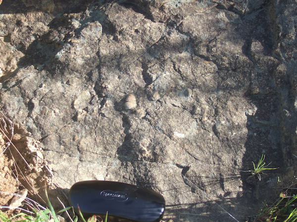
Schistose sandstone pebbles incorporated in the stone can still be seen but the outlines are blurred as a result of the metamorphosis
Bluschist within a beach exposure on Angel Island
Metamorphosed pillow lavas
Short History of San Francisco
San Francisco developed rapidly as a port and urban centre following the California gold rush in 1849. Following extensive damage in the 1906 earthquake, the city was rebuilt in time to host the 1915 World Fair, which established the city as a significant world trade centre.
Nowadays, the city is better known for hippie culture and lifestyle, for tourism and for the adjacent silicon valley enterprises.
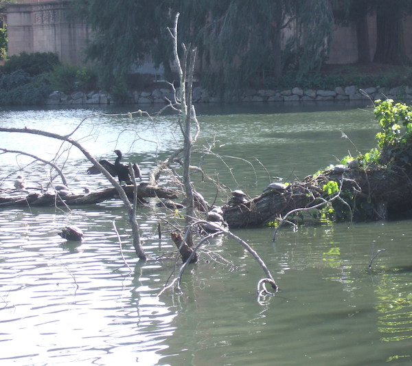
Lake at the Palace of Fine Arts
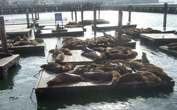
Sea Lions in the Fisherman's Wharf area on the northern edge of the city