Summer weekend North Norfolk 2017
This year the club decided to take a look at the Quaternary geology of north Norfolk, which would be a complete change from our local geology. The leader was Tim Holt-Wilson who is well known for his work on the geodiversity of Norfolk. His knowledge and previous work in the area led to a highly interesting and informative weekend.
The solid geology of Norfolk is mainly covered by Quaternary deposits, although in some areas the underlying rock does appear at the surface as at Hunstanton where the cliffs are composed of Cretaceous age rocks. The oldest rocks are to be found in the west and these dip gently eastwards towards the north sea basin. The oldest rocks are Lower Cretaceous sandstones and clays, which form an eroded escarpment between Heacham and Castle Rising, and underlie much sandy heathland locally. Rock types vary from sands and impermeable clays to tough, iron-cemented sandstones. Overlying these rocks are rocks of the Upper Cretaceous chalk which contain numerous flint nodules.
As you move eastwards the chalk becomes overlain by Pliocene-Pleistocene marine sands and gravels, these being the Norwich Crag and the Wroxham Crag Formations resting unconformably on the chalk. Other “pre-glacial” deposits are the freshwater and estuarine deposits known as the Cromer Forest Bed.
The overlying superficial deposits are very complex and it is these that we had really come to see. Ice-sheets and seas transgressed and regressed many times over this landscape which left a complex sequence of marine and terrestrial sediments. Between about 2.6 million and 900,000 years ago, Southern England was joined to France, at the Straits of Dover, which now links the North Sea to the English Channel. Numerous small-scale oscillations from warmer to cooler episodes occurred resulting in frequent but relatively small falls and rises in sea level, which would have affected the Norfolk coastline.
Around 900,000 years ago, a marked climatic shift occurred, resulting in a climate dominated by extremes both globally and locally. During this time over 20 major climatic shifts from ‘warm stages’ (or interglacials) to ‘cold stages’, (or glacials), have been recognised globally, with each lasting several tens of thousands of years. During the maximum extent of glaciation, ice covered the whole of the British Isles north of Bristol and London. The thickness of ice over Norfolk is estimated to have been between 2 and 3km. At least three major glaciations have been recognised: the earliest of these is called the Happisburgh Glaciation and started around 640,000 years ago. The second, and largest glaciation is the Anglian Glaciation and occurred around 450,000 years ago. The third glaciation, which didn’t extend as far into Norfolk, is known as the Devensian glaciation which was at its coldest around 25,000 years ago. Each of the glaciations dramatically modified the geography of Norfolk and deposited vast quantities of sediment.
Sandringham warren
The first location on the Saturday morning was Sandringham Warren and Dersingham bog (TF 6694 2839) where Tim showed us landscape features related to Lower Cretaceous geology. It is here that sands of the Leziate Beds ( Sandringham Sands Formation, Upper Jurassic to Lower Cretaceous) are capped by harder, iron-rich layers of basal Dersingham Beds (Dersingham Formation). Leziate Beds consist of loose, quartz rich sands and iron-cemented sandstones and were laid down under marine conditions.The Dersingham Beds the basal of which are iron-cemented sandstones, overlain by sands, silts and clays. The Dersingham Beds produce the plateau feature seen at Sandringham Warren. Tim explained that a series of bluffs separated by dry valleys is thought to represent a line of a former cliff and the dry valleys a product of a process known as “spring sapping” where groundwater outflow undermines slopes and therefore cuts back into the slope forming a valley. Dersingham bog which is a SSSI, is developed on layers of poorly draining sandy “head” washed down from the Leziate Beds and is now an acid mire. It has many rare plants like bog ashphodel, round-leaved sundew and cranberry.
Snettisham Common Pit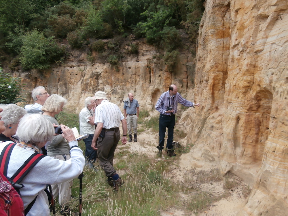
We then drove to Snettisham Common Pit (TF 6710 3362) which is a county wildlife site and turned out to be a superb sandstone quarry from which high silica sandstone had been quarried in the 19th century for use as foundry sand. The quarry has vertical exposures up to 5m in height of Leziate Beds topped by strata of the Dersingham Beds. The sands showed good examples of cross-bedding and the walls of the quarry were peppered with the holes from solitary bees. One important feature in the quarry is faulting which may be associated with glacial loading or periglacial cambering.
Lunch at Ringstead Common
A short stop at Heacham chalk pit where the Lower Chalk (Grey Chalk, Upper Cretaceous, Plenus Zone)is exposed. It was here that Mike Hodgson found a very large ammonite, and although worn, was impressive. The next stop was Ringstead Common nature reserve, for a well earned lunch before we looked at the geology. Middle Chalk ( white chalk, Upper Cretaceous, Labiatus Zone) is exposed here. Ringstead is an example of an outwash valley. During the decline and melting of the North Sea ice-sheet valleys in central and western Norfolk were deeply excavated by the action of torrential melt-water streams issuing from the margin of the retreating ice. Ringstead is the result of a former drainage overflow channel that was cut by the melting ice water. Lots of examples of chalk flora were also present.
Cliffs at Hunstanton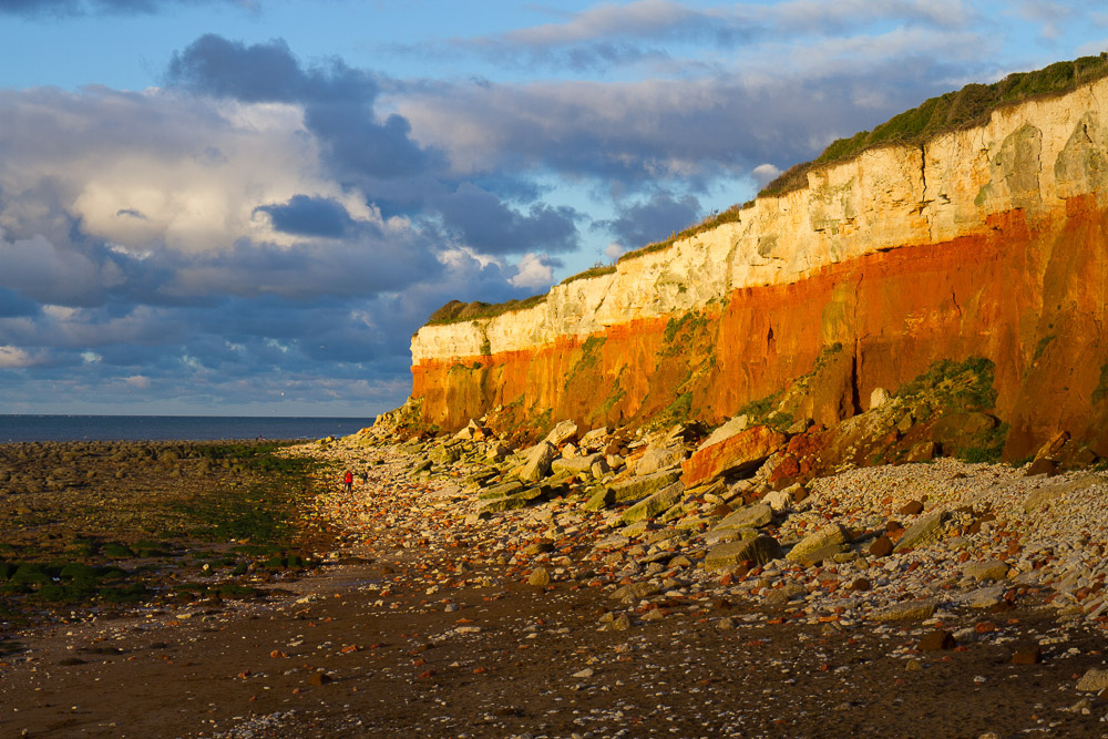
We returned to Hunstanton ( our base) and after an ice-cream on the sea front spent the remainder of the day observing the cliffs at Hunstanton (TF 673415). The cliffs extend from Hunstanton to St. Edmunds Point, Old Hunstanton, about 1.5km away, and the whole is a SSSI of Cretaceous deposits. The colour contrast of the rocks is impressive with, at the base, the rusty brown of the Carstone Formation to the red of the Hunstanton Chalk Formation ( Red Chalk) to the white and grey of the Ferriby Chalk Formation. As the cliffs dip to the east, at St.Edmund's Point the Red Chalk is at beach level and the Carstone is no longer visible.
The Carstone is formed of coarse sand particles interspersed with rolled pebbles indicative of deposition in a high energy, shallow sea, near shore environment, with strong currents. The lower Carstone is Aptian in age (112-116ma) whilst the upper Carstone is Middle Albion (105ma). When it is fresh the Carstone is grey-green in colour but darkens to brown with weathering. On the foreshore the Carstone forms a strange pattern of ‘tuffets’, where the sea has preferentially eroded joints in the rock.
Above the Carstone is the Red Chalk (101ma) and it is thought there was a gradual transition from one to the other. The more pebbly Carstone being laid down in a higher energy and shallower environment to the finer Carstone. The Red Chalk being laid down very slowly in deeper water but close enough to land to receive iron-rich clay. When the sea-level rose sufficiently the land was completely flooded and only white chalk was deposited. The Carstone contains fossils including ammonite fragments, bivalves and traces of burrowing organisms, whilst the fossils of the Red Chalk include belemnites, brachiopods, echinoids and corals. The lowermost bed of the White Chalk also contains numerous fossils including, bivalves, brachiopods, belemnites, echinoids. Between the top of the Red Chalk and the base of the Ferriby chalk is the Paradoxica Bed. This was originally named from what was thought to be a sponge but in fact turned out to be sediment-filled, anastomosing Thalassinoides burrow systems.
Paramoudra or Pot Stone 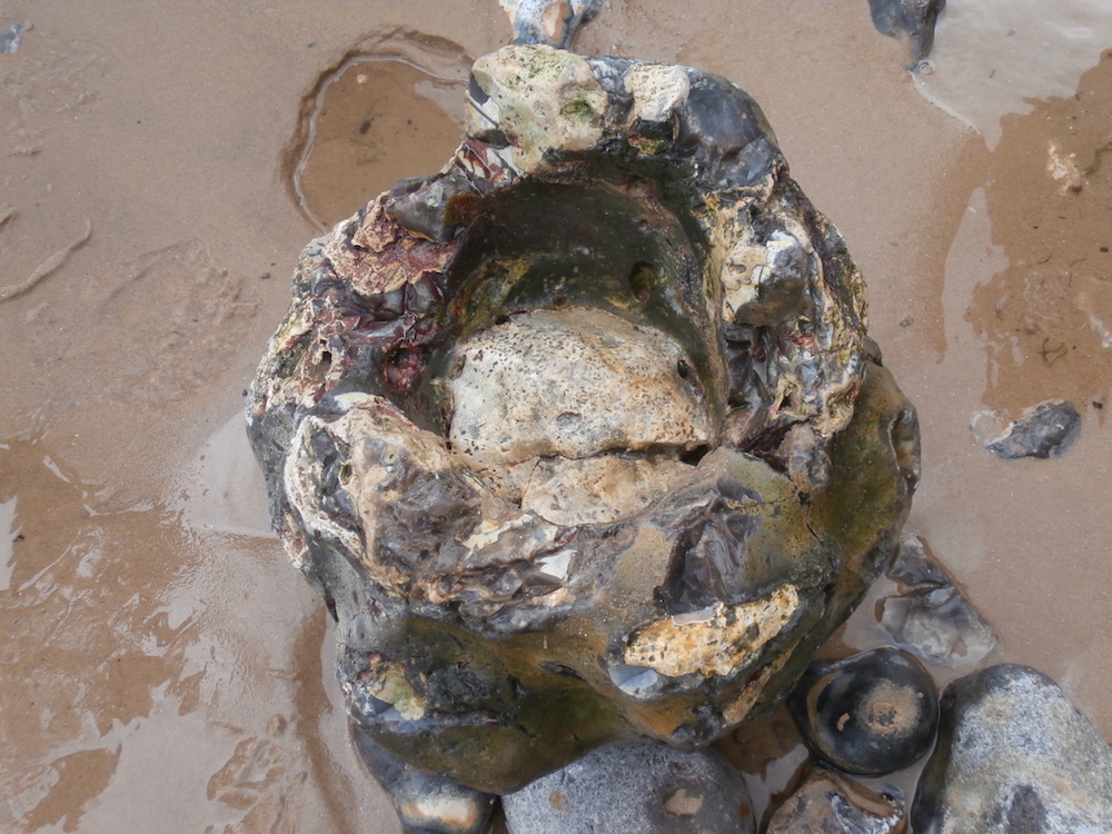
On the Sunday our group went east to spend the day to try and gain a basic understanding of the Quaternary geomorpholgy. Our first stop was west Runton. ( TG 185432) where the Cromer Forest bed is the Type site for the Cromerian Interglacial Period. The area is a SSSI because of it's rich fossil beds and one of the most important Quaternary sites in the UK.It is famous for the elephant or steppe mammoth, Mammuthus trogontherii, which was discovered in 1990 and is one of the oldest and best preserved fossil elephants ever found in the UK.
Commencing on the beach we are standing on a chalk wave-cut platform and there are large flint circles and other flint structures which resemble garden pots. These are the Paramoudra or “Pot stones” which are trace fossils of an unknown creature and referred to as Bathicnus paramoudrea. As we work up the succession the Wroxham Crag lies unconformably on the chalk. This is a shelly deposit and is pre-Pastonian to Cromerian in age. The shells are marine bivalves that are cold water species and herald the onset of the glaciation.
Overlying the Wroxham Crag are the Cromer Forest Beds which according to the BGS Lexicon can be described as follows: “The formation encompasses the fluvial, lacustrine and organic deposits of the postulated "Ancaster River", which is believed to have flowed from the Pennines to the North Sea along a line corresponding approximately to the present north coast of Norfolk. Four members are recognised in north Norfolk coastal sections. The Sheringham Member (lowest member) comprises freshwater organic mud, clay and sand. The Runton Member includes laminated freshwater silty clay. The West Runton Member comprises layers of alluvial clay and organic freshwater mud. The Bacton Member (highest Member) comprises clay and organic mud.”
The Cromer Forest bed has yielded the richest Pleistocene vertebrate fauna in UK and include, fish, amphibians, reptiles, birds and mammals. The upper part of the Cromer Forest Bed the layers become gravelly and marine bivalves are present indicating a return to marine conditions.This, along with cross bedding suggest esturine conditions. Above the Cromer Forest Bed Formation are glacial deposits belonging to the Anglian Stage. They consist of a complex sequence of fluviatile sediments and contorted drift which demonstrate a climate cooling from the interglacial to glacial conditions. They include river sands, gravels, glacial till and outwash sands. There is remarkable folding in the glacial sediments the consequence of glacio-tectonic deformation.
Glacio-tectonised strata at Weybourne Hope
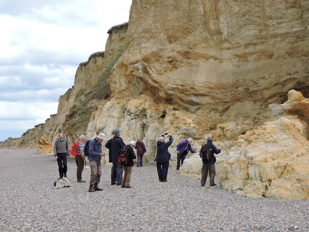
From West Runton we travelled to Weybourne Hope. The overall first impression was of high cliffs of contorted soft sediment very unlike any glacial till in mid-Wales. The lower cliffs are composed of the Weybourne Chalk Member (Norwich Chalk, Upper Cretaceous, Campanian), which are glacio-tectonised where sub-horizontal shear planes have occurred due to glacial ice movement. This is chalk breccia in which fractured flints and fragmented shells occur. Above the chalk is the Wroxham Crag Member (Early Middle Pleistocene) as seen at West Runton but is disturbed and distorted due to the effects of glaciation. Above the Wroxham Crags Formation are Members of the Sheringham Cliffs Formation (Middle Pleistocene), the Runton Till Member a matrix-supported diamicton and the chalky Weybourne Town Member which is a highly consolidated matrix-supported diamicton. Above these there is a sharp erosional boundary and then the Briton's Lane Sand and Gravel Member of the Briton's Lane Formation (Late Pleistocene).
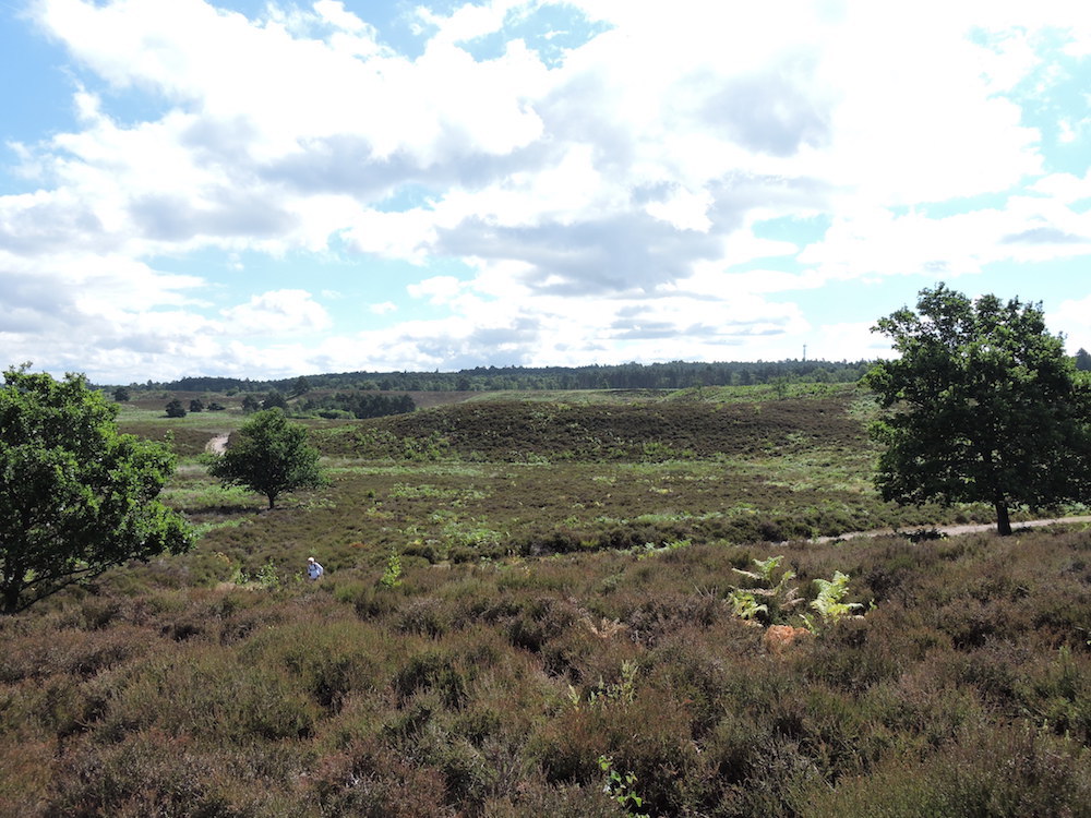
We then visited Blakeney Esker ( TG 031422), apparently the best in England. An esker is a long winding ridge of sand and gravel which has been deposited within a tunnel made by a subglacial stream cut into the base of an ice sheet. They are not normally preserved very well as the loose sand and gravel are washed away by melting ice sheet. The esker is 3.5km long and runs from Blakeney to Wiverton, with a base width of 100m. This is also a wildlife site and the differences in the geology are reflected in the plants at the top and bottom of the esker. Those at the top are acid heath type plants where as those at the base are growing on clay.
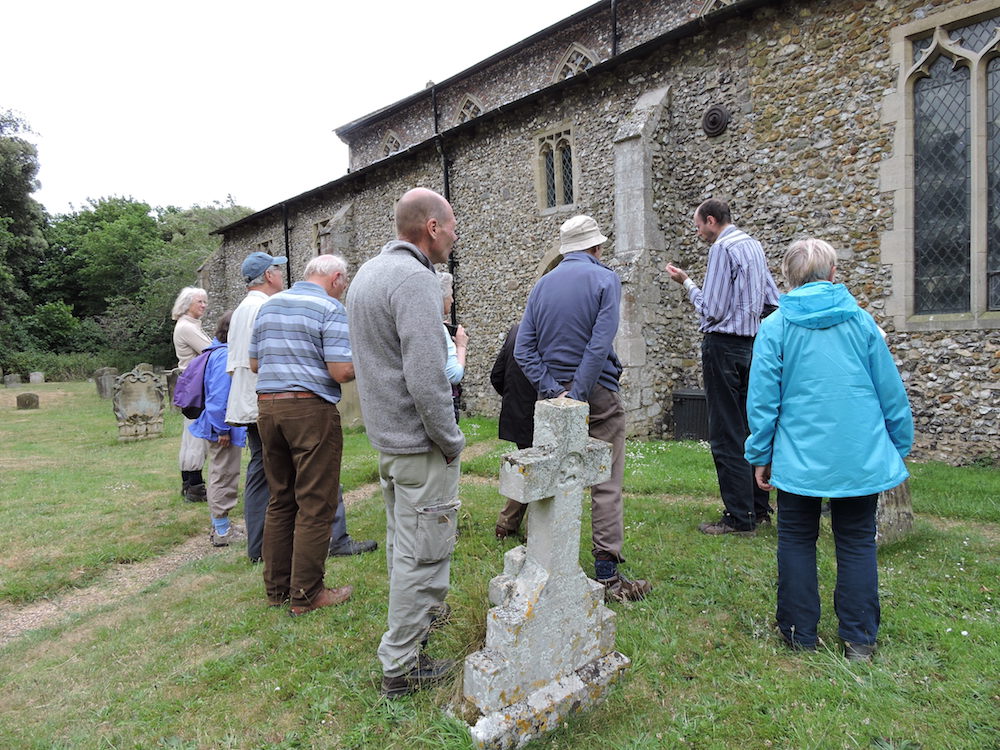
Our final stop was to St. Mary's church Brancaster to look at the building stones in it's walls. This is something the club is well used to undertaking. The church building is known for the re-use of Roman stone in the walls. There are the remains of two Norman windows in the south side of the west end of the chancel and these have been blocked in by stone taken from the Roman Fort of Branodunum. It was also used as a facing stone and isolated stones were found dotted around the walls. The stone is a very distinctive quartzite and comes from quarries around Castle Rising.
Building Stones Brancaster Church