Summer Weekend Field Trip to Gower 9th - 11th September 2022 led by Prof. Kokelaar
Summer Weekend Field Trip to Gower 9th - 11th September 2022 led by Prof. Kokelaar
The weekend commenced with a talk by our leader Prof Peter Kokelaar ( retired George Herdman Professor of Geology University of Liverpool) which covered the general geology of the area and also his own findings from the work he had carried out on Gower.
Gower is composed almost entirely of rocks of Devonian and Carboniferous age with only remnants of the once extensive Mesozoic cover. The Devonian rocks comprise the Old Red sandstone (ORS) which were deposited in arid to semi-arid environments.These rocks are divided into red marls and brownstones ( lower ORS) and quartz conglomerate (upper ORS) which are separated by an unconformity. The ORS form the highest ground on Gower and occur in the cores of anticlines. The high ground of Cefyn Bryn, Llanmadoc Hill and Rhossili Down are anticlines consisting of ORS.
The main bulk of the rocks of Gower are comprised of Carboniferous Limestones with deposits greater than 1000m. These rocks were laid down after marine transgression over the ORS with further regression/transgression sequences over time culminating in the typical facies of Carboniferous rocks i.e. Carboniferous limestone, Millstone Grits and the Coal Measures.
Towards the end of the Carboniferous period the Variscan Orogeny propagated from the south in a northerly direction causing extensive folding and faulting of the Devonian and Carboniferous rocks.
The whole of Gower was affected by ice on numerous occasions. The last glaciation, the Devensian, reached a maximum about 18,000 years ago and destroyed many of the features created by previous glaciations and is responsible for most of the glacial landforms preserved in Gower today.
Port-Enyon Bay
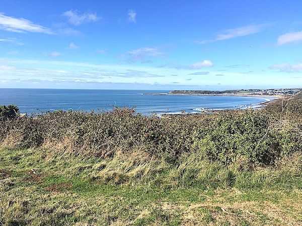
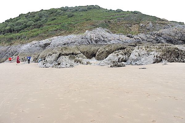
On a gloriously sunny Saturday we parked in Oxwich and then walked, with various stops, to Oxwich Point.
Port-Enyon bay like Oxwich bay lies in the core of a syncline with the softer Millstone Grits ( Marros) being easily eroded to form the bay. From our vantage point, at the first stop, we could view the solifluction terrace alongside Port - Enyon bay. This is almost a flat terrace that ends in a steep bank at the beach. This was produced during the last glaciation ( Devensian) when glaciers reached northern Gower and the area would have had an Arctic Tundra type climate with permafrost. Freeze -thaw action on the rocks lead to rock fracturing producing rock fragments. During summer thaw water could not drain through the frozen ground so that it became unstable and slid down the slopes leading to a thick layer on the rocks below and hence the terrace.
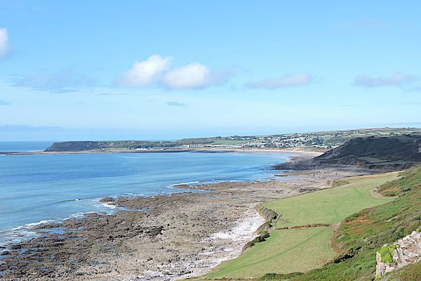
Solifluction terrace Port-Enyon Bay
Prof. Kokelaar then went on to explain why when looking at the high surfaces one can see that they appear to be level. In fact they are sloping platforms at approximately 60m,120m and 180m. These are thought to be marine abrasion platforms that have been uplifted in pulses. The breakdown of the limestone in a marine environment is due to a number of processes of weathering and erosion which include wave action, sea water depositing salt crystals in cracks in rock which expand on heating fracturing the rock ( known as haloclasty), wetting and drying, splash and spray impact, mixing corrosion, dissolution, and biological action,
He then explained that the most probable cause of the pulsed uplift was related to a mantle plume which was originally centred in the area of western Scotland, north-eastern Ireland and east Greenland. He suggested “that continuously flowing fluids like in the hot mantle in a plume do not move steadily though the cooler mantle but form a series of waves or blobby pulses. Therefore uplift would have been pulsed leading to the stepped nature of the landscape.” The landscape would then be weathered and eroded as seen.
At the second stop we examined minerals that occurred as fault fracture fill. The site was usually covered but storm waves had led to the site being temporarily visible. The mineralisation was superb. The layers consisted of mm scale calcite, and haematite layering with some paler yellow presumably limonite present. It was explained that the colour banding reflects compositional and/ or temperature variations of the fluids forming the minerals through time. These fissures in which the mineral fill occurs form along or around faults in the upper few kilometres of the crust. These fissures can form in one of two ways either by displacement along a fault leading to the production of a void or by solution along faults or joints can create fissures in for example limestones, although the two are not mutually exclusive.
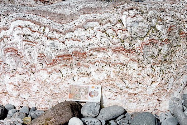
Fault fracture fill
Along our way to the last stop we viewed and discussed the origin of the slades. Slades are the short dry valleys that cut into the flat - topped cliffs. There have been various explanations for their formation but Prof Kokelaar suggested that the simplest solution is that they are remnants of minor karst valleys that existed before the late Pliocene marine planation. Therefore the upper reaches of these valleys were originally greater and then were shaved off by by the marine planation.
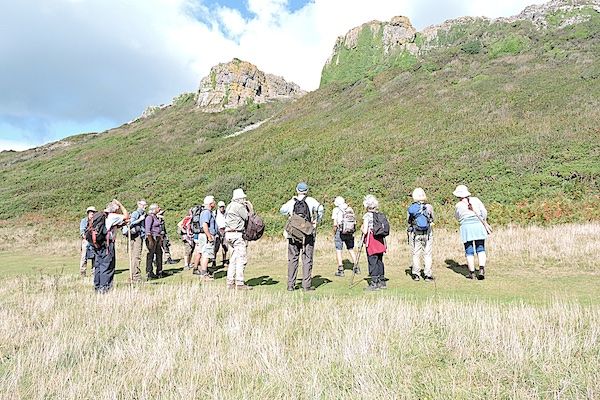
Discussing Slade formation
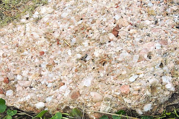
Our final stop was at a part of the beach which led to quite a discussion. This is one of the sites where what is known as Patella beach deposits occur and these deposits are also found at various other sites from Mumbles Head to Worm’s Head. The deposit is composed of various pebble, cobble and breccia conglomerates with a matrix of coarse sand and gravel. It is highly fossiliferous and the name Patella derives from it’s large content of limpet shells ( Patella Vulgata). Periwinkle and dog whelk are also present. These organisms live in the littoral zone.
The Patella beach is Late Pleistocene in age and interpreted as the result of a single exceptional storm with associated storm surge that caused debris to be catastrophically dumped beyond the reach of normal storm waves.
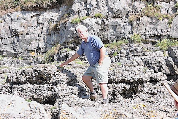
Prof. Kokelaar explaing the formation of the Patella Beach Deposit
The Sunday turned out to be misty and cool a complete turnabout from the previous day.
Our first stop was to the top of Cefyn Bryn at which point fleeces and windproofs were required. From the carpark we followed the path which runs north and stopped at the Bronze Age Round Cairn which comprises a massive collection of erratics which are representative of the area. The erratics consist of large numbers of quartzites along with UORS quartz-pebble conglomerates and LORS Brownstone Fm sandstones.
Quartz conglomerate
We then followed the path to the Neolithic burial chamber known as Maen ceti or Arthur’s seat. Prof Kokelaar explained that the chamber consists of a huge capstone and is supported by plinth stones. The capstone is a glacial erratic composed of quartz -pebble conglomerate from the north crop. It has an “exposure age” of approximately 23000 years and as it is an erratic some 300m from the southern limit of the Devensian ice it records the time of the Last Glacial Maximum.
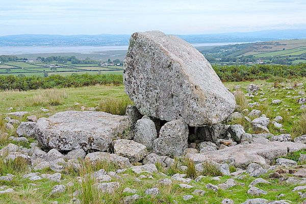
Maen Ceti (Arthur's Tomb)
Lunch was taken atop Cefyn Bryn followed by the final excursion to Caswell Bay. We parked in the carpark and then walked onto the beach. An added bonus was the presence of Mediterranean gulls amongst the Black-headed and Lesser Black-backed gulls on the shore.
Caswell Thrust
Walking along the shore we passed where the Caswell thrust intersects the cliffs. Here the Langland Dolomite has been pushed up and over the Caswell Bay Mudstone. We carried on around the corner to a section of low limestone cliffs which we then scrambled up. The limestone was fine-grained ( micrite) and were covered in micro-rills. The micro-rills were narrow up to 2mm and were either straight or sinuous in shape. It was explained that they are an erosional structure caused by water flowing along the limestone via surface tension effects underneath sand. Prof. Kokelaar went on to explain that if the rills do in fact form under sand and as sand was now absent from these cliffs then at some point in the past the sand-dunes must have been banked up along the cliffs. In other words the sand has been washed away over time most probably due to storms.
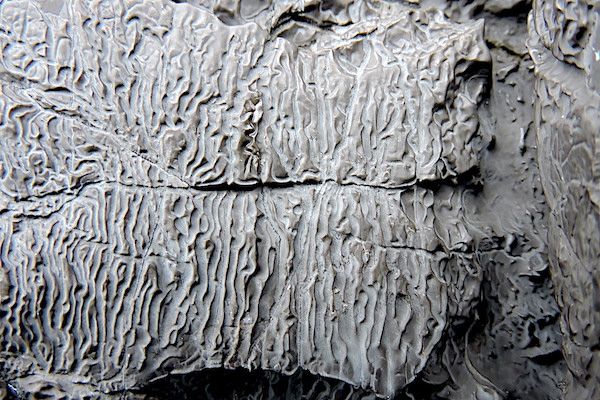
Micro-rills on Micrite
This was our last venue and the end of a very informative weekend.