Amongst other things, we saw impressive exposures of Carboniferous Limestone with cyclothems, paleokarstic surfaces, fossil corals, brachiopods, plant debris, fluvial deposits of Silurian pebbles on an eroded Carboniferous surface and massive cross bedding in sandy oolitic limestone - or was it a limey sandstone? There were lots of things to puzzle out.
Parking for several cars is at O.S. ref SJ 234432.
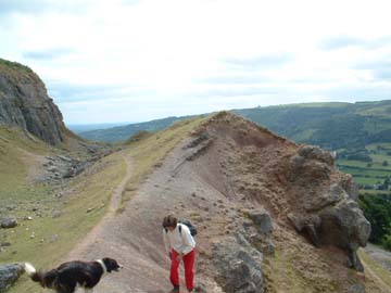
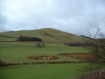
From parking, take the path up the old incline, NW, and along the old tramway (You can see the occasional sleeper still.) to location 1. (SJ 231433) From here we get a good view of the local geology and the Dee valley. Castell Dinas Bran, facing you, is on Silurian (Ludlow) as is the lower ground below the road. The base of the Carb. limestone is shown on the map as faulted along the line of the road, which may be so, but the base is also a major unconformity, corresponding to it being above sea level during the Devonian.
The Carboniferous sea slowly transgressed over the eroded Silurian landscape during the Early Carboniferous (Dinantian) ~337Ma, covering S. Wales and later, N. Wales. The early Dinantian is therefore missing. Along the road below, "Basement Beds" outcrop sporadically in stream beds, these represent the "first washings" and are red shaley rocks.
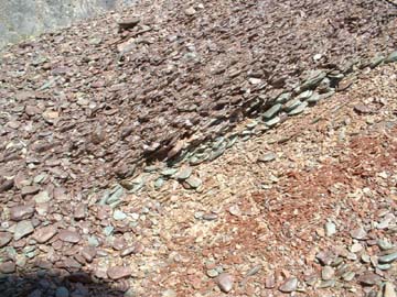
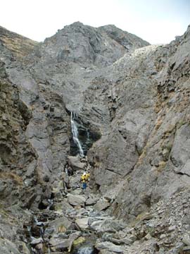
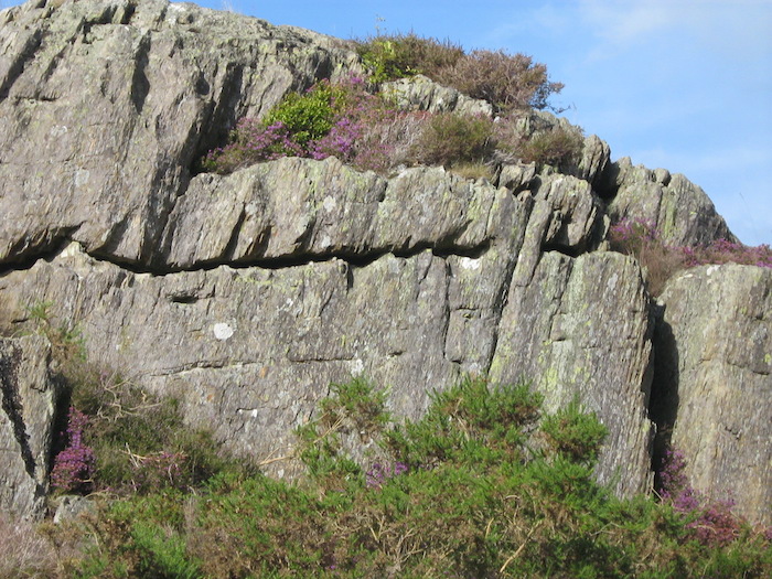
The beds below loc 1 are the Upper Ty-Nant Lst Fm with the Eglwyseg Lst coming in at loc. 1 . Above the small scarp, in the gap, there is a sub-aerial eroded paleokarstic surface filled with a purple and green pebbly shale with Silurian pebbles showing imbrication.(Pics 1&2)
Pic 1Pic 2
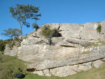
The next higher quarry face shows nice cyclothems, perhaps better appreciated at loc. 2, where there are half a dozen. These are produced by repeated transgression and regression of sea level. Wales was at the time sub-equatorial and water was locked up in a S. polar ice cap, with periodic inter-glacials. Periodic emergence is indicated by paleokarstic surfaces, with more rubbly beds, rust coloured calcretes, dessication cracks etc. (In one place, further round by Ty-Nant there is actually a thin coal seam. ) The bottom bed is a massive cream limestone (biopelsparite) bed with a hummocky paleokarstic top surface and rubbly layers. Above that in the next massive bed is an interesting "pseudobreccia" which can be examined in fallen blocks.
Following round to the east, higher beds can be examined as far as the end quarry, beloved by climbers. There are examples of colonial corals, burrows, etc. Above the quarry is an example of a limestone pavement.
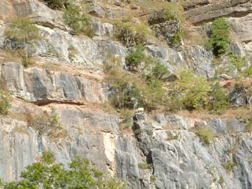
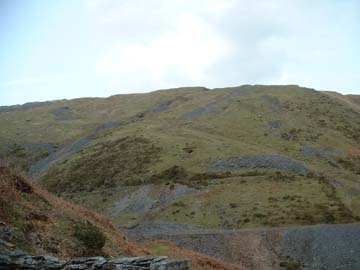
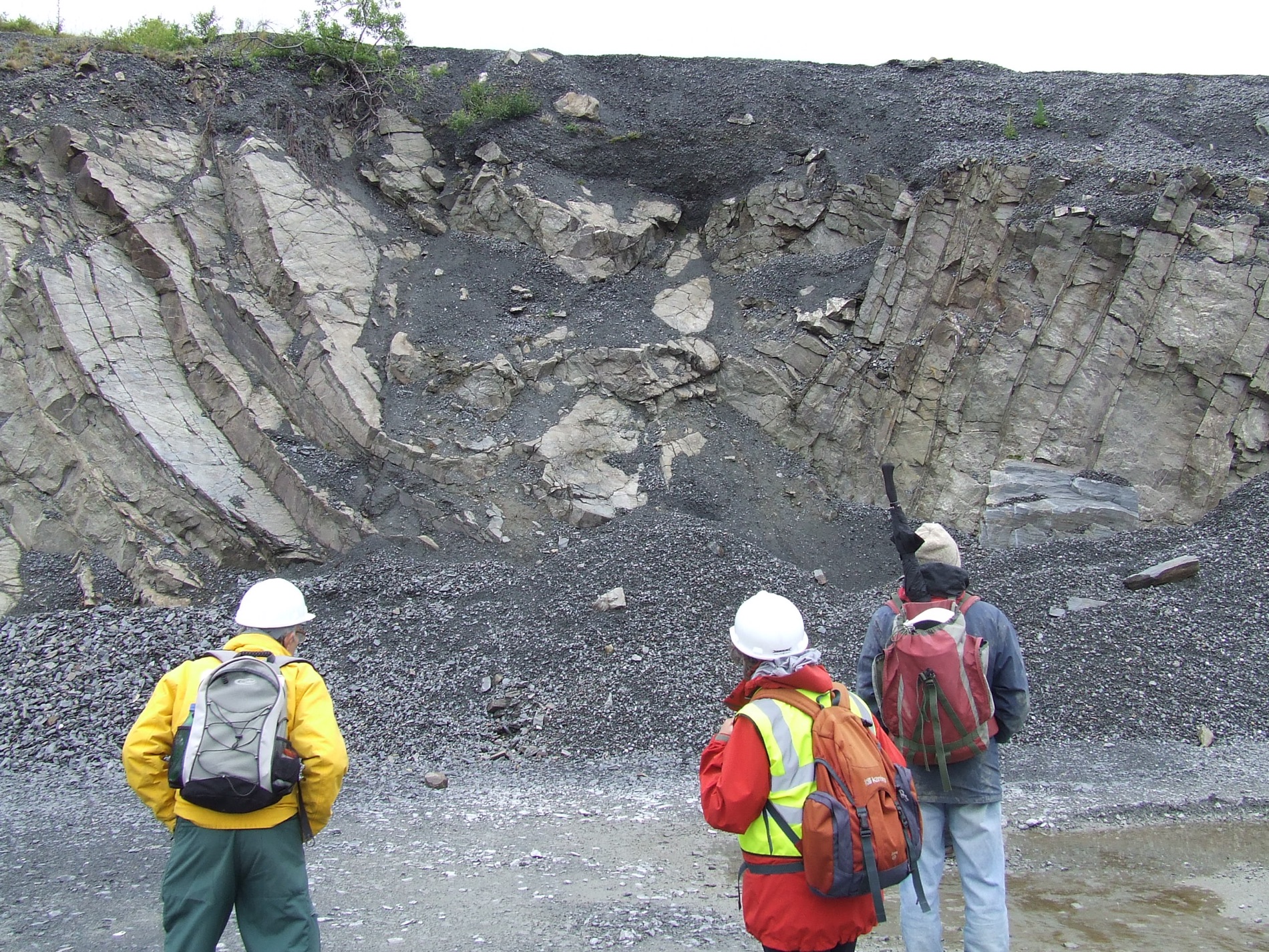
A path can be followed back to the car parking for a cuppa and a sandwich, before taking a path to the ESE towards loc 2, (SJ 240428) Bron Heulog Quarry. This large quarry has a sheer face exposing nearly 200 feet of the Eglwyseg Limestone and shows really impressive cyclothems.
SAFETY NOTE Falling rocks from 200 ft are dangerous. Keep clear of the faces and wear your hard hat!
At the east end of the quarry impressive lime kilns are well preserved. (watch the unprotected edge!) Here lower beds of the Eglwyseg Lst are exposed (normally not seen as they erode easily) comprising green and grey marls and rubbly micrites with grey fetid biosparites and calcareous shales.
On the way back clean specimens of all lithologies can be found in the broken blocks, including examples from the Sandy Lst Fm (loc 3) and the overlying Cefn-y-Fedu Sst.
Location 3 (SJ 227455) is reached a mile or so east along the road but there is good parking so it is excusable to drive. This is in the Sandy Lst Fm and shows remarkably good large scale cross stratification, with conglomerates with quartz pebbles, nice deltaic structures. With a lens they are lovely oolitic sandy limestones and limey sandstones. Are the regular beds tidal? monsoonal? or what? This is a textbook face so, please, no hammers, but there is plenty more round the corner if you did not pick up some at loc. 2.
Pic 3 - Massive cross bedding at loc. 3Pic 4 - Loc. 2 Bron Heulog Quarry
Refs G.A. Guide "No.6 Geology around the University Towns - Liverpool 1986
Brit Regional Geology North Wales. (At present O/P. Mine is prehistoric and dated 1948 price 3s.6d. but I think there is an issue about 1976.
"Pingo" is the Eskimo word for a hill and applies to the large number of almost circular hills found in the Canadian North West Territories round the Mackenzie Delta. They rise to up to 60 metres high by 600 metres wide and some have a central crater which may contain a circular pond. Within each there is a core of ice which builds up as a large lens pushing up a dome of sediment above it. Eventually the dome splits and the ice is exposed and can melt in the summer.
In Britain all we have left after the last ice age are circular ramparts filled with boggy sediment. They are rare in Wales. In the field at Tylwch we saw a good example with traces of another nearby.
Note that the pingo is on private land so do not traspass without permission, there is little point because there is nothing on the ground and it is best seen from the path which overlooks it to the north.
Do be careful because there are lots of farm ponds which are just that, Pic 6 shows one near Guilsfield!
Pic 5 - A pingo near TylwchPic 6 - Not a pingo, near Guilsfield!
M.R.Dobson 1995 "The Aberystwyth District" G.A.Guide No. 54 ISBN 0900717785 pp77-80
Cave R. and Haynes, B.A. 1986 Geology of the Country between Aberystwyth and Machynlleth Mem. Brit.Geol. Surv. Sheet 163 pp119-120
Leaflet No. 7 "The Temple Lead Mine" available, with others, from the M.W.Mining Museum, Ponterwyd, Aberystwyth. This museum is well worth a visit and is 2km west of Ponterwyd on the A44.
The walk starts at Yspyty Cynfyn, (SN752791) on the A4120, 2km south of Ponterwyd, where there is parking, (avoiding obstructing the church or barn entrance!). It follows a classic section described by O.T.Jones in 1909, defining the graptolite zones of the Cwmere and Derwenlas formations at the bottom of the Llandovery Series (Base of the Silurian). It includes the remains of Temple Mine which is a significant mine on the Castell fault. All the underground workings are dangerous and should not be entered. That said, hard hats are not required for the walk, just good boots and sandwiches.
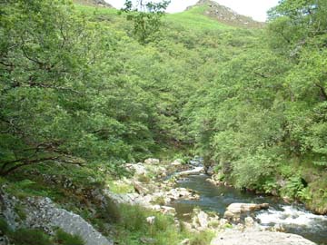
Set off to the right of the churchyard, in the wall there are built in the standing stones of an old stone circle. This gave it's name to "Temple Mine". We follow the path a few hundred yards and down into a steep sided dingle where we cross Parson's bridge.
This structure replaces an earlier plank bridge which must have been a bit "hairy". It was used by the parson to visit his flock in Ystumtuen, which was a mining community above the gorge. The volume of water in the river was much greater before the power station took the majority of the flow, but it is still impressive. Note the enormous potholes. These are about as good as you get.
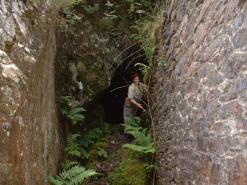
We bear right over the bridge, and 100 yards further on find the ruins of the dressing floors of Temple Mine. Dating from the 1880's, the ore bins, circular buddles, wheelpit and crusher base are clearly visible. The waste tips went straight into the river so there are few minerals etc to be found here. The ore used to be hauled up an incline to meet a track to Ystumtuen. The path up the slope is now overgrown and difficult to find. Continuing along the path, we are walking along the line of the tramway between the main adit and the dressing floors. The leat which fed the 14ft waterwheel is a few feet to the left.
Shortly we come to the main adit on the left with a very substantial wheelpit on the right below the path. This housed the waterwheel which ran plant, pumps and the winding gear.
50 yards on we cross a small tributary. This is an important location as both the tributary and the Rheidol follow the Castell Fault. This is a major feature along which mineralisation occurred. There is an old adit (Nantymoch level) about 50 yds up the tributary but it is quite a scramble to get to it.
The path now follows the old leat and graptolites can be found in rock exposures along it. You need to get your eye in for them as the slatey cleavage does not follow the bedding and the graps are on the bedding plane. The importance of these organisms is that they evolved rapidly and therefore make good zone fossils. In the Aberystwyth area in particular, we have a situation where, along the coast, we have a section along the cliffs where, in the north, the dip is to the south and, in the south, it is to the north. (i.e. basin-like) Because the sediment was deposited by north flowing currents, one stratum could well be a sandstone in the south and a mudstone in the north. In about 1909 graptolite zones were used to establish which Aberystwyth Grits in the south corresponded to particular Borth Mudstones in the north.
It was the noted geologist, O.T.Jones who mapped the area using graps for zoning.
(Ref: Jones, O.T. 1909 The Hartfell-Valentian succession in the district around Plynlimon and Pont Erwyd Qt. Jl. geol.Soc.Lond.,65, 463-537)
By a small oak, the path bears up and left. The leat continues to a steep cliff where it was carried in a timber box section, chained to the cliff face. The path approaches the river again before a scree slope and a stile into a field. Most of O.T.Jones' sections are in this 400m section south of the stile. Graps are mostly located in the rusty weathering rocks, rather than the pale ones.
It has to be said that there are hundreds of species of grap, so they are not easy to identify. However, some from here are quite pretty, being pyritised.
The public path goes north through Brynbras farmyard and bears right, following their track to the George Borrow Hotel. As the most interesting bits are in the south, we returned that way. An interesting feature in the north is that the river meanders. It was thought that these were "incised meamders" formed when sea level was higher and the river was mature. Sea level then went down and the river was rejuvenated, cutting the meanders deeper as it did so. It is now thought that the more likely explanation is that the river burst out above an ice blockage during the ice age. The meanders can be seen from the road, in various places.
The return path up the ravine above Parson's Bridge always seems steeper and longer going up than coming down!
Simon J.S.Hughes, 1980 "British Mining, No. 17" Northern Mine Research Soc. (The most complete guide)
M.R.Dobson 1995 "The Aberystwyth District" G.A.Guide No. 54 pp89ff ISBN 0900717785
D. Bick 1991 "The Old Metal Mines of Mid-Wales" Pt 4 24-25
The Cwmystwyth mine (SN 805746) is at the west end of the old mountain road to Rhayader, just off the B4574.
Cwmystwyth is one of the largest of the old mines, to the north of the road are most of the workings and remains of the dressing floors.
Mineral specimens (Galena, sphalerite) can be found both sides of the road in the extensive spoil tips. Further to the north east is Copa Hill which has remains of uncertain pre-historic date with the best examples of the old "hushing" process. This involved damming water and releasing it to clear the topsoil exposing any signs of veins.
Cwmystwyth mineLooking towards Copa Hill Back to top
Rocks of the Elan Valley Reservoirs
Sunday 28 April 2013 (leader: Colin Humphrey)
The roads which wind around the exceptionally beautiful and peaceful reservoirs of the Elan and Claerwen valleys reveal the Cerigwynion Grits which ended the Ordovician here, and the mudstones which began the Silurian. Rising and falling sea-level 440 million years ago produced a range of different types of deep-water sediment deposition. This sandstone and mudstone succession was deposited as a series of gently sloping lobes with slumps, debris flows and a wide range of turbidites. An unusual feature is the record of a very different depositional environment, the Caban Conglomerates, an erosive high energy submarine channel flow which cut through the sandstone/mudstone slope-apron and left its own story in the rock. Local folding (Rhiwnant Anticline) followed by natural erosion and man’s rock cutting and has left different rock facies conveniently juxtaposed.
CARN OWEN – Sunday 19 May 2013
John Mason led a sizeable group to Carn Owen and Esgairhir mine on a cold sunny day to do what members seem to like best: searching for fossils and collecting minerals. Carn Owen lies just west of Nant y Moch reservoir so we were able to enjoy a long drive around the reservoir on the way out and back. Carn Owen is a ridge close to the NW tip of Nant y Moch reservoir. The hard Upper Ordovician sandstones of the Drosgol and Brynglas Formations are exposed along the axis of a NNE aligned pericline (dome structure), with the younger, softer, shaley Cwmere Formation rock exposed around the flanks. The contact between the two is strikingly obvious in the change of slope. We have been to the lead mine before but this time we were taken to a spoil tip near the top of the tramway incline at SN 7308 8802. Tipped here on Ordovician sandstone is a huge pile of rusty weathering Cwmere shales with abundant Nomalograptus persculptus, the characteristic graptolite of the lower Cwmere, together with numerous small orthocones.
Next call was the nearby and more recent rock quarry at SN 732 881, a highly disturbed sandstone channel displaying great contortions of the bedding, which also incorporate huge mudstone diapirs resulting from upward squirting of still soft mudstone as large bodies of sand flowed onto them. This melange is thought to result from collapses of the south-eastern levee (banking) of the submarine channel. Finally, in a small quarry at SN 734 881 we saw the contact between the uppermost Brynglas sandstones and the lowest Cwmere mudstones, and discussed the reasons for the oxic condition of the former and the anoxic condition of the latter. Then we lunched in the sunshine.
The afternoon was spent at Esgair Hir mine, located just north of Nant y Moch, at SN 733 913. There were at least a dozen phases of mineralisation as superheated mineral rich fluids were released upwards from their deep reservoirs by movement on faults. It began work in 1693 and continued sporadically until 1904, producing a total around 2000 tonnes of lead ore and some 700 tonnes of copper ore. But it is best known for the small quantities of a silver ore, tetrahedrite, found in the lead ores, allowing silver to be reclaimed during smelting. We found on the spoil tips: chalcopyrite, marcasite, malachite, pyrite, galena, sphalerite and goethite, and various secondary minerals which have formed in recent times from weathering of the original primary minerals, including cerussite, pyromorphite, azurite, linarite and ferroan dolomite; over a dozen minerals in total, not bad for two hours searching, and everyone found a few minerals. Then John told us that he has found around forty minerals in total on these very tips over many visits!
Middletown Quarry
Our visit to Middletown Quarry last Sunday was most enjoyable, perfect weather and unusual rocks. It is within the interesting Breidden inlier, north west of Welshpool which comprises an heterogeneous mix of Ordovician rocks all within a small area.
The main quarry is mostly within the Lower Rhyolitic Tuff member of the Middletown Formation (Ordovician, Caradoc). It is a rhyolitic tuff/breccia which is strikingly green - even brighter green if wet. The bedding reflects the different volcanic events and shows variation in colour and in the grading of the clasts within it. The green colour is thought to be due to the replacement of minerals within pumice by chloritic minerals. The image is of explosive eruptions of an island volcano producing ash which is carried down into deeper water by turbiditic flows.
The Lower Rhyolitic Tuff member is overlain by the Graptolitic Shale member and the Upper Rhyolitic Tuff member in the upper benches of the quarry. Although we could see the Graptolitic Shale Member, which is a dark "Black Shale", we could not approach it and had to content ourselves with examining different heaps around the quarry. Some was heavily pyritised, like the black colour, showing it originated in anoxic conditions. Graptolites were hard to come by, however.
One strange rock in the main quarry raised questions regarding its derivation. It as a conlomerate in which the clasts were "cobbles" of bentonite. Presumably derived from a soft sediment mass flow of partially lithified sediment in which ash had already been degraded.
At the top of the quarry and on the hilltop above, an andesitic conglomerate with andesitic cobbles overlies the Middletown Formation. This is in the Builthy Formation and may indicate that the volcanoes were becoming more intermediate in nature.
In the afternoon, after discussing the surrounding geology from the vantagepoint of the hilltop, we explored more of a section across the Breidden inlier by walking across the valley towards Rodney's Column, noting the change of slope and the dolerite exposures as we came to the intrusion exploited by the nearby Criggion Quarry.
Gaer Fawr
The May 2014 fieldtrip was led by Tony Thorp on and around Gaer Fawr Hill near Guilsfield, on the western flank of the Guilsfield anticline. We were near the top of the Gaer Fawr Fm (Ordovician, Caradoc), a shallowing-up sandstone with abundant fossils, as seen in the small quarry at the nature reserve car park. This hard sandstone forms the hill. Above this in the steeply dipping sequence is the softer Dolhir Fm (Ashgill), which has now eroded to a valley. The Ordovician is then topped by the Nod Glas, a thin horizon of soft black shale, which we saw in the stream banks at the valley bottom. Above this in the sequence is the very hard Powis Castle Conglomerate, a beach deposit, now forming a ridge, along which we walked, looking across the eroded valley, at Gaer Fawr Hill. All these features were beautifully evident on a lovely dry day, with additional features to be seen in the stream bed (bentonites, evidence of faulting, and limestone). The day finished with a walk to the top of the iron age hill fort, through woods of stunning bluebell display.
Gilfach Geology
On the 16th July, a dozen members of the Mid Wales Geology Club spent the evening exploring the geology of Gilfach Nature Reserve.
Fresh rock by the entrance
“Gilfach Crags - Concretions in one bed, eroded away”
In some ways Gilfach geology is simple as all the exposed bedrock is from just one formation, the Rhayader Mudstones Formation. In the reserve, exposures are generally weathered and covered in lichen; but there is a comparatively fresh exposure just outside the entrance on the A470 road cutting, where we could examine it at close quarters. (Watching the traffic!) Here it was seen to be an attractive green-grey fine grained rock in which individual grains are too small to be visible to the naked eye, hence it is classified by geologists as a "mudrock". It was laid down some 430 million years ago in quite deep water and is part of the Llandovery Series of the Silurian System.
Cleavage, bedding and joints
The rocks show a marked directional “grain” at a steep near vertical angle dipping (or sloping) towards the northwest. This is nothing to do with the beds as they were deposited, but is “cleavage” developed much later by tectonic strain at moderate temperatures and pressures. It is less developed than in slates, so these mudrocks would be termed shales.
Picking out the signature of the original bedding was more difficult. It shows as more subtle changes in colour and texture which can be picked out dipping much nearer the horizontal. On some cleavage faces the bedding shows as a ripple effect when the direction of cleavage differs slightly as it meets different beds. This is known as “cleavage refraction” and is caused by the cleavage tending to align itself more towards the bedding direction of muddy beds as compared to sandier ones. The bedding here is quite thin, being from a few cm to tens of cm. Each bed represents an “event”, specifically a muddy flow from a shallower shelf area in the east into deeper water here. It could have been triggered by a storm or similar disturbance and is termed a turbidite. Each turbidite could have been followed by a quiet period in which very thin laminae may have been deposited from the undisturbed waters above. These are termed hemipelagites and may be dark grey, pyritic and carbonaceous if deposited in anoxic conditions, with no life surviving; or lighter grey and mottled with burrows if animals lived there.
Other near vertical faces are “joints”, which are produced much later as pressure on the rock is reduced as it is brought nearer the surface by earth movement and erosion.
Concretions
“Potholes in the river Marteg”
One of the notable features of this rock is the presence of concretions or nodules. These commonly form in mudrocks after deposition and are discrete local patches cemented differently from what surrounds them. They can be cemented by a variety of minerals; but in this rock they are generally either calcareous or phosphatic. In the road cutting we found one which was about 150 mm long and egg shaped. It fizzed when we touched it with acid, so was calcareous (cemented by calcite) and it showed a cone-in-cone structure. Cone-in-cone structures are poorly understood. They comprise nested cones of fibrous calcite and probably take a long time to form, requiring that a high proportion of saturated pore water remains within the sediment for hundreds of thousands of years. This can occur if a bed is overpressured by being trapped between impermeable layers. As rock is much denser than water, under these conditions pressure can be greater than that due to a simple water column.
There were also many smaller phosphatic nodules disposed along the bedding. These are blacker than the surrounding rock, but get paler as they weather.
Folds and faults
Walking back into the reserve and up to the crags on the hillside facing the parking, we saw similar directional features. The cleavage was again steeply dipping in the same north westerly direction and this was to turn out to be true all over the reserve to within a few degrees. It is a “regional cleavage” and is remarkably consistent over a large area.
The bedding, however, told a different story. We could see it was dipping in different directions as we looked round. In some places it was folded into synclines (downward) and anticlines (upward). Displacements in the bedding occurred where small faults existed.
Some beds had been partially eroded away where lines of concretions had been preferentially eroded out.
The story of the rocks
The structure of these rocks tells of a complicated story going back some 430 million years to a time when Wales was attached to the north of small continent which geologists call Avalonia. This was somewhere south of the equator, drifting slowly north towards a larger continent, Laurentia, later to become North America. It was starting to feel a soft collision with Laurentia. This was complicated by it not being a straight head-to-head collision, but at an angle, with some transverse movement. Further complication was introduced by the probable impact of another continental fragment, Baltica, from the east. The three way collision did not produce simple concertina folds, but something more like a crumpled sheet of paper, which is what we see in the variously dipping bedding planes. Cleavage developed much later (about 390 million years ago) in the Devonian period when the collision pressure peaked just as today in the Himalayas, where the Indian sub-continent is in collision with Asia.
To the recent stuff – The Quaternary, or Ice Age
What went on more recently during the Ice Age? The Wye valley going north is wide and there are ice eroded cwms exiting into it, so it was ice filled; but to the south it is much narrower and gorge-like so ice could well have been forced up the Marteg valley. (Ice can, of course, flow uphill on occasion!) It may even have been forced north as well, to join the great ice stream exiting along the Severn Valley.
The craggy hill tops could have been exposed, particularly in later periglacial times, when they would have been exposed to freeze-thaw conditions, producing quantities of “head”, comprising debris of all sizes down to small flakes, quantities of which we found in the ditches alongside the road as we walked up the valley and down to the river.
In the river itself there are some of the best potholes you will find anywhere, some quite “Henry Moorish”! No doubt the cavities left by eroded concretions helped start the potholing process. Pebbles carried by the river in turbulent eddies when in spate complete the process by abrading, expanding and making the cavities circular.
Typically the deposits on the north of the river appear to consist of head while those on the south are grey till, deposited from ice. Perhaps the early river established its gorge to the north of the ice-filled valley, where the sun thawed the ice first.
In places we saw a level red layer below the top of the till which had resisted erosion by the river. This could be a lithified layer, hardened by deposits of iron oxides, forming a pan.
This was indeed an enjoyable evening walk along one of the loveliest river valleys in Mid Wales, with a geological story as a bonus. If the opportunity of a repeat performance were to arise, a full day would be well justified, with a visit to the visitor centre for tea and a cake!
Hendre quarry Ystrad Meurig
Thirteen members enjoyed a day of glorious April sunshine at Hendre quarry (by permission of Hanson), five miles south of Devil's Bridge, led by Dr David James. Hendre (SN 721693) is a working quarry, on the eastern flank of the Teifi Anticline, which is the western upfold of the first order fold structure of Central Wales. The main quarry is several hundred metres across, with faces all round, allowing a nearly 360 degree view of folds in the Ystrad Meurig Grits. Here the Hendre Lobe of sandstones, within the Lower Silurian, Derwenlas Formation mudstones, was sourced via a channel from the Caban canyon, near Rhayader, 25-30 miles away, on the shelf edge of the Lower Palaeozoic Welsh Basin.
We saw turbiditic sandstones of the various stages of the Bouma classification, and some flute casts which proved the palaeocurrent was flowing roughly westwards away from the basin shelf into much deeper water; though the relative absence of mudstone intervals restricts the development of flute casts in these grits. Grading could be seen in some thick sandstone units. Large blocks on the central quarry floor show beautifully colour-banded cross sections and allow hand lens examination of contacts and grading. Groove casts and prod marks are also visible on these blocks. Often the rock is made up of a continuous sequence of sandstone units, but in places the sandstones are interspersed with dark mudstone in which graptolites have been found. Folding is well displayed in the quarry, with some folds traceable north-south across the quarry. The benches provide ample opportunity for interpretation and discussion of fold structures, some of which contain confusing parasitic folds and complicated by minor faults. With folds so well displayed, their asymmetry reveals the dominant vergence in a south-east direction, recording the Caledonian Orogeny. There are good examples of the open, rounded structure of folds in competent, thick sandstones, and tighter chevron folds in thinner sandstones. The all-round views of quarry faces allow cross sections of structures to be seen on one side, and large areas of slightly rippled and curved bedding to be seen on other sides.
Following in Darwin's Footsteps
Our September field trip, on the 20th, followed "In Darwin's footsteps" under the leadership of member Roy McGurn. Our meeting point was at the first location, Pen y Foel Lane, Llanymynech, where Roy explained the background to the dozen assembled members.
In August 1831, England's foremost geologist, Prof. Adam Sedgwick, set out on an expedition to map the "transition beds" of Wales, that had hitherto defied meaningful interpretation. The period was one of dramatic change in the understanding and concepts of geology. Although a biblical interpretation (according to Genesis) was not seriously regarded by many researchers by this time, the concept of some kind of creation was still strong.
For the previous 50 or so years, the theories of Abraham Gottleb Werner had held sway, that the rocks we see are the result of some sort of fluvial action, perhaps floods or deposits left by a retreating sea. The school of thought was broadly known as "Neptunism". Sedgwick himself had used his presidential address to the Geological Society to recant his belief in this theory that very spring.
The succeeding counter argument, perhaps broadly termed Plutonism, was the development of ideas presented by James Hutton in his two lectures to the Royal Society of Edinburgh as far back as 1788. Hutton had postulated the rock cycle, with rocks constantly being renewed from igneous rocks breaking through to the surface from great depth. Hutton could see no sign of a beginning , nor any sign of an end to this process, which finally challenged any concepts of a divine creation, which also postulated a day of judgement.
It could be said that Copernicus challenged the concept of the earth being at the centre of the Universe. (He was wise to publish his works when more or less on his death bed, as in his day such ideas would have amounted to Heresy.). Hutton challenged the idea of a biblical creation, again another heresy in an earlier time. In the summer of 1831, the third prophet who was to eventually challenge man's place at the centre of creation, began his journey here.
It is perhaps how fate works that the grandson of Hutton's friend, Erasmus Darwin, who invoked some ire himself with observations on the immutability of species was asked to accompany Prof. Sedgwick on his quest.
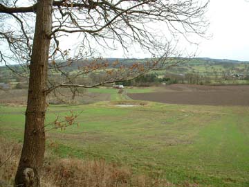
A few yards up the lane, they stopped and no doubt could see in the road cutting, steeply dipping shaley rocks on which Darwin could try out his newly acquired clinometer (a small plaque marks the spot). From this spot they could see the nearby limestone escarpment and quarries of Llanymynech Hill. These are almost flat and, if projected, would have been overhead at this point. These radically different dips would indicate an unconformity, as taken by Hutton to show a break in succession and maybe a period of erosion.
The second location was on Trevor Rocks, above Llangollen, with a view of Castell Dinas Bran and up the Dee valley. Sedgwick had business in Llangollen, with Robert Dawson, a surveyor, who was to furnish him with notes on the limestone of the Vale of Clwyd.Sedgwick's mission was very vividly set out for him here. The prominent Mountain Limestone, as it was known is easily identified by its distinctive lithology. It was known elsewhere for the "Herefordshire Beds" to occur beneath the Mountain Limestone, again with a fairly distinctive lithology. Below the Herefordshire Beds, into deepest and darkest Wales, the lithology was a lot less distinctive and geologists at the time were having great difficulty making any sense of it. It was generally referred to as the transition beds..
Sedgwick needed to find a sequence of strata that took him down into the transition beds and from which he could derive fossil sequences to identify them. Ideally following the maps of the time, he needed to follow a sequence down from the Herefordshire Beds. (= Old Red Sandstone). Sedgwick was using a later version of Greenough's map that had partially corrected the Herefordshire Beds error. The red sandstone in the Vale of Clwyd had identified as New Red Sandstone, a rock common in England and known to be some way above the Mountain Limestone. However a small sliver of exposed rock was still indicated below the Mountain Limestone and was known as the Old Red Sandstone.
At this location the scree covers the base of the limestone. Tantalisingly traces of red soil may be found in places along here, a possible indicator of red sandstone (Old or New) beneath.
As Dinas Bran is significantly higher than the base of the limestone, even if the latter is "extrapolated" towards it, there seems to be something else happening between the two. A small fault is marked on the modern maps which must take the southern side up a little, so any base to the limestone will have been above the hilltop and hence long eroded away.
Sedgwick was not going to find much to help him here.
The third location was at Velvet Hill, next to the road up to Horseshoe Pass, at the entrance to Valle Crucis Abbey. Darwin's enthusiasm for his new clinometer is evident, he records:
"Saturday 6th August Vale of Crucis.
The bank above the abbey consists of Clay slate, which breaks at regular intervals, striking nw by n, d,25 to the ne by n. at different parts road observed beds of diluvium very Shrops only no sand:also boulders of trap."
The entrance to the abbey contains a small well. This is likely to have been the original road and the well may well have been a stop Sedgwick made to water his horse ahead of the long climb up Horseshoe Pass. Darwin busied himself with his notebook and clinometer.
Darwin went on to note.
"Beyond Vale of Crucis on the road to Rurhven the Limestone is seen having a grand escarpment to the west: The contrast between this and the more regular slope of the Clay Slatew gives more grandeur to the views. The Greywacke generally covered by gorse, Heath and Fern: the limestone either bare or the verdure very green." However Darwin's observation shows how they were using geomorphology to identify the outcrop of limestone. Beyond the pass the escarpment changes, with the rounded, heath covered greywackes he noted, seeming to break into the line of limestone hills, and the limestone outcropping into the greywacke area.
Next Step. Darwin notes "About 1/2 mile beyond Daforn, a black bituminous Limestone organic remains veined quartz in parts reddish in one part strata exactly arched. The line N by E."
This note refers to a disused quarry at Plas Newydd where, indeed we found limestone crags, reddish in parts. No arch, but much limestone may have been removed.
Darwin goes on "1/2 mile further a tortuous valley through Clay Slate generally dipping to the E. About a mile from the Ruthven beds of sandstone"
This is Nant y Garth, the faulting brings up the Silurian beds again and forms the end of the Vale of Clwyd. At its end, the road opens into a plain with hills either side, especially a clear line of them to the north. We are into Triassic New Red Sandstone, but outcrops are rare although the soil is red.
Appropriately, we ended our trip at the Castle Hotel, now a Wetherspoons, where Sedgwick and Darwin spent the night. Darwin notes:
"Ruthin: takes its name from the new Sandstone on which it is built. The soil is for some miles about the town and the plain may be considered of that formation. In most places covered up by diluvium. Mile to the west of the town a quarry of worked. The rock is spotted with brown the stone at Cardeston. Overlying Magn conglomerate. It is very irregular strat but the rock on which the castle is built nearly horizontal seams. petrifications this there are some beds of Old red Sand striking the same ways as the overlying stone but dipping at a greater angle. A further is more clearly visible in a water"
The elusive ORS has finally reappeared and Sedgwick may have thought he had an opening into the lower succession, the notes stress this rock is UNDER the limestone and does have all the appearance of the beds found in Herefordshire. However the boundaries into the lower beds are generally faulted here, in its simplest form the Vale of Clwyd is a rift valley, down faulted during the Upper Carboniferous-Triassic. Sedgwick was not to find a succession into the transition beds anywhere in North Wales, as the unconformity Darwin didn't observe way back in Llanymynech represented a break in deposition and a period of erosion that covered the entire Devonian period and the beginning of the Carboniferous.
Members had enjoyed a fascinating trip and Roy's research and leadership were really appreciated. Most members started to return home at this point, but noted that Ruthin contained a remarkable assortment of building stones, particularly evident in St. Peter's Church, where Sedgwick and Darwin attended Matins on Sunday 7th August 1831. They perhaps viewed the pot-pourri of stone used in its construction.
Ruthin seems worth a full day trip in its own right. Perhaps we could follow more footsteps at a future date.