Climate change and coastal heritage in Wales - insights from the palaeo-environmental record
At the last indoor (Zoom) meeting Prof. Sarah Davies ( Head of Geography and Environmental Sciences Aberystwyth University) gave a highly interesting talk entitled “Climate change and coastal heritage in Wales - insights from the palaeo-environmental record”
Prof. Davies is involved in a collaborative project known as CHERISH, i.e. Climate, Heritage and Environments of Reefs, Islands and Headlands. The works covers both Ireland and Wales and there are four partners:
Royal Commission on Historical Monuments of Wales, lead on the project.
Aberystwyth University
The Discovery programme - Centre for Archaeology and Innovation Ireland.
Geological Survey, Ireland.
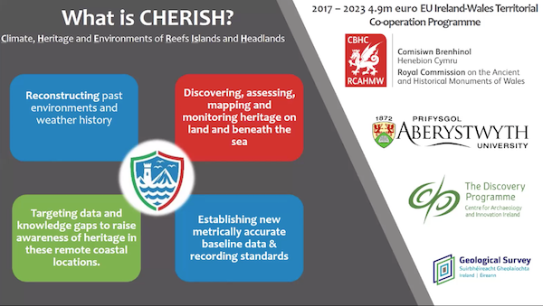
Using an array of techniques and a land, sea and air approach the project has the following aims:
Reconstructing past environments and weather history.
Discovering, assessing, mapping and monitoring heritage on land and beneath the sea.
Targeting data and knowledge gaps to raise awareness of heritage in these remote coastal locations.
Establishing new metrically accurate baseline data and recording standards.
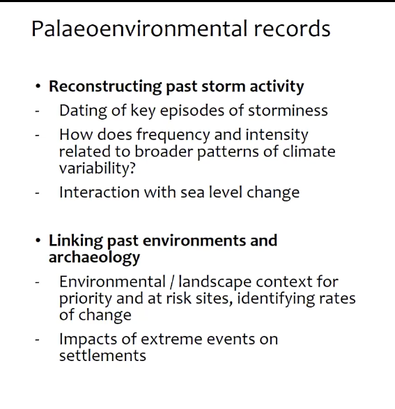
Although the project covers both Ireland and Wales Prof. Davies focused her talk on Wales and the Holocene Period. Her team are focusing on trying to put some contemporary climate change problems into a longer term context i.e. the last few millennia. Using palaeoenvironmental records and a range of physical techniques they are examining coastal wetlands, lakes, bogs and sand dune systems, with the aim to date past storm activity and how periods of storminess have changed over time in frequency and intensity. The link to sea level change is also important.
The palaeoenvironmental evidence can also be used to link to the archaeology to provide environment and landscape context and how changes affected the societies at the time.
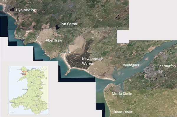
One study area covers parts of north Wales( Anglesey and Gwynedd) with different sites of different types and putting the data together from these sites it is hoped to develop a picture of change. These areas can be seen on the map below.
A key tool in the research is luminescence dating which allows dating of when minerals, especially quartz, was last exposed to light. In other words it is a burial signal for the minerals.
Prof. Davies then went on to describe the work undertaken at the Welsh sites. From the work undertaken a whole range of evidence has been obtained which is allowing them to build a picture of landscape and environmental change which can be integrated with the archaeology. This is aiding in the longer term understanding of environmental and climatic change and how past societies coped with those changes. This knowledge may help with the changes which we are undergoing now and in the future.
Photos with kind permission of speaker